Candy Hansen wrote:Frosty Alcoves on Kaiser Crater Dunes (ESP_045614_1330) (HiClip)
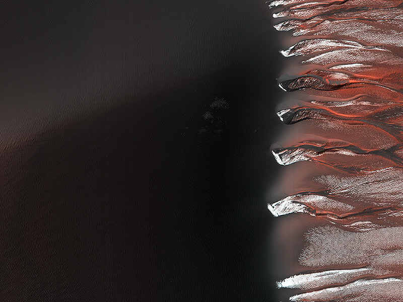
Kaiser Crater hosts a large field of sand dunes. Every winter the dunes are covered with a layer of seasonal carbon dioxide ice (dry ice). In early spring the ice begins to sublimate (going directly from solid ice to gas).
In this image, the dunes are partially free of seasonal ice, with the contrast making it easy to see the ripples. Deep alcoves have been carved at the crest of the dune. We hypothesize that this is the result of the gas coming from the dry ice, destabilizing the sand at the crest. As blocks of ice protected in the cold shadows of the alcove break off they slide downslope, carving the channels we see.
Alfred McEwen wrote:The Color Wonderland of Mawrth Vallis (ESP_045747_2030) (HiClip)
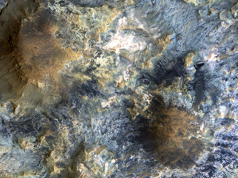
There is a candidate landing site in the Mawrth Vallis region for the European Space Agency's ExoMars rover, planned to launch in 2020. This is one of the HiRISE images acquired to evaluate this site.
Mawrth Vallis has some of the most spectacular color variations seen anywhere on Mars. This color variability is due to a range of hydrated minerals—water caused alteration of these ancient deposits—which is why this site is of interest to study the past habitability of Mars.
Henrik Hargitai and Ginny Gulick wrote:A Streamlined Form in Lethe Vallis (ESP_045833_1845)
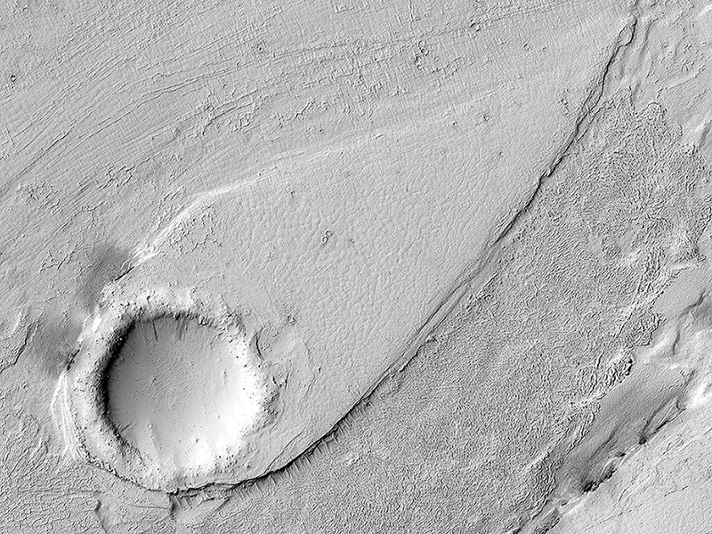
This image shows a portion of Lethe Vallis, an outflow channel that also transported lava. Another investigation of this area (Balme et al., 2011) discovered a repeat pattern of dune-like forms in the channel interpreted as fluvial dunes (or, giant current ripples) which are dunes formed by flowing water.
This is one of only a few places on Mars where these pristine-appearing landforms have been identified. The channel formed by catastrophic floods, during which it produced the prominent crater-cored, teardroped-shaped island in the middle. The island has the blunter end pointing upstream and the long tail pointing downstream.
Both the island and the fluvial dunes were formed by these extreme floods and their size is an indicator of the enormous discharges required to create them. The margins of the channel also show the terminal front of a pristine lava flow unit that inundated the channel from the south and the dunes show the remnants of another older lava flow. The top of the island displays polygonal patterned ground texture, which is a characteristic of periglacial processes in ice-rich ground.
The dark materials from the channel and island walls are probably dark sand being eroded from an underlying horizontal basaltic (lava) layer. The crater at the core of the island has elongated dunes and reticulate dust ridges inside. This single image thus contains features formed by periglacial, volcanic, fluvial, impact, aeolian and mass wasting processes, all in one place.
This is a stereo pair with ESP_044989_1845.
Alfred McEwen wrote:A Human Bird's Eye View of Mars (PSP_006633_2010)
There have been several proposals to send people to Mars but not land them on the surface. Instead, they would either fly by Mars once and return to Earth, or orbit Mars for a period of time. Would they at least get spectacular naked-eye views of the Martian surface?
Some parts of Mars would be interesting: for example the polar ice caps, and the bright (dust-covered) regions would be seen reasonably well, although the color is very uniform. The dark (low reflectance) regions of Mars are some of the most interesting and important regions studied by our orbiters and rovers, but they would appear very bland to humans outside of the planet's atmosphere. This is because the thin atmosphere of Mars is quite bright and dusty, so when looking at dark surface areas, most of what you would see is scattered light from the atmospheric dust, and the surface would have a very low contrast. It would also appear reddish, even if the surface materials are not reddish, from the scattered light.
Here is an example from the Nili Patera region of Mars, a candidate future landing site. At the top is an approximation of the natural color as seen by people with normal color vision--almost no surface detail is visible. In the middle is the standard HiRISE IRB color product, consisting of the infrared, red, and blue-green images displayed as red, green, and blue, respectively, and with a min-max stretch applied to each color. In other words, the darkest pixel in the entire image is set to black, the brightest pixel is set to white, and all others are linearly interpolated. At bottom is an enhanced color product, in which each bandpass is given a linear stretch for the local subimage, sometimes saturating a small percentage of data to black or white to give the rest of the scene more contrast, followed by color saturation enhancement. Now we can see a diversity of colors that distinguish different surface units: dust, sand, and rocks with different minerals.
This is a stereo pair with PSP_007556_2010.
Credit: NASA/JPL-Caltech/University of Arizona
<< Previous HiRISE Update


