Page 1 of 2
APOD: Earthset from the Lunar Orbiter... (2016 Jan 04)
Posted: Mon Jan 04, 2016 5:13 am
by APOD Robot
 Earthset from the Lunar Reconnaissance Orbiter
Explanation:
Earthset from the Lunar Reconnaissance Orbiter
Explanation: On the Moon, the Earth never rises -- or sets. If you were to sit on the surface of the Moon, you would see the Earth just hang in the sky. This is because the Moon always keeps the
same side toward the Earth. Curiously, the
featured image does picture the Earth setting over a lunar edge. This was possible because the image was taken from a spacecraft
orbiting the Moon - specifically the
Lunar Reconnaissance Orbiter (LRO). In fact, LRO orbits the Moon so fast that, from the spacecraft, the
Earth appears to
set anew about every two hours. The
featured image captured one such Earthset about three months ago. By contrast, from the surface of the Earth, the
Moon sets about once a day -- with the
primary cause being the rotation of the Earth.
LRO was launched in 2009 and, while creating a detailed three dimensional map of the
Moon's surface, is also
surveying the Moon for
water and possible good landing spots for
future astronauts.
[/b]
Re: APOD: Earthset from the Lunar Orbiter... (2016 Jan 04)
Posted: Mon Jan 04, 2016 10:44 am
by Jeddo
Given the moon's libration
https://en.wikipedia.org/wiki/Libration#Lunar_libration the Earth is not hanging in the same spot of the Moon's sky but tracking an irregular circle – and judging by the significant wobble I would expect this circle to be larger than the Earth's diameter. Consequently, standing on a convenient spot on the Moon's horizon, you _would_ see earthrises and earthsets, though of course not in the opposite directions of the horizon but occurring rather close to each other. One each in 28-odd Earth days.
Re: APOD: Earthset from the Lunar Orbiter... (2016 Jan 04)
Posted: Mon Jan 04, 2016 1:26 pm
by rkcoker
The mind wanders a bit somewhat like the Earth in the lunar sky, but the first thing I thought of when I saw today's APOD was the opening to the movie "Independence Day." Silly me!

Re: APOD: Earthset from the Lunar Orbiter... (2016 Jan 04)
Posted: Mon Jan 04, 2016 2:02 pm
by madman56
Is the atmosphere above northern Africa really that transparent? Why aren't there more observatories there?
Re: APOD: Earthset from the Lunar Orbiter... (2016 Jan 04)
Posted: Mon Jan 04, 2016 2:05 pm
by Boomer12k
What struck me was 1...the Sahara...WOW...
2..how smooth everything seems on the Moon. You would think with no erosion, it would be more jagged, and rough. But it all looks like ONE SMOOTH ROCK...
3...how "rumpled" the highlands look....
Simply gorgeous image.
:---[===] *
Re: APOD: Earthset from the Lunar Orbiter... (2016 Jan 04)
Posted: Mon Jan 04, 2016 2:38 pm
by Ron-Astro Pharmacist
Would all planets with liquid water on the surface appear blue or are there other contributing factors? Ocean or atmospheric chemistry, sunlight, water depth or surface conditions, atmosphere only?
Only answer I could find. Color might seem like a good way to spot other habitable exo-planets.
Re: APOD: Earthset from the Lunar Orbiter... (2016 Jan 04)
Posted: Mon Jan 04, 2016 3:03 pm
by Chris Peterson
madman56 wrote:Is the atmosphere above northern Africa really that transparent? Why aren't there more observatories there?
The atmosphere everywhere is very transparent, assuming no clouds. Transparency isn't usually the primary factor we look for when siting observatories. What is generally more important is the total column of air we're looking through, since that affects the steadiness of the image. This is also impacted by regional airflow patterns. And, of course, weather is important. The Sahara is often cloud free, which is good. But in other respects, it is not.
Re: APOD: Earthset from the Lunar Orbiter... (2016 Jan 04)
Posted: Mon Jan 04, 2016 3:04 pm
by Chris Peterson
APOD Robot wrote:If you were to sit on the surface of the Moon, you would see the Earth just hang in the sky.
There is nearly half of the lunar surface where you could stand and never see the Earth at all.
Re: APOD: Earthset from the Lunar Orbiter... (2016 Jan 04)
Posted: Mon Jan 04, 2016 3:27 pm
by Cousin Ricky
I studied the image, and deduced that it was taken either in October or in late February/early March.
Then I read the description.
I'm pleased with myself!

Re: APOD: Earthset from the Lunar Orbiter... (2016 Jan 04)
Posted: Mon Jan 04, 2016 4:50 pm
by neufer
Chris Peterson wrote:madman56 wrote:
Is the atmosphere above northern Africa really that transparent? Why aren't there more observatories there?
The atmosphere everywhere is very transparent, assuming no clouds. Transparency isn't usually the primary factor we look for when siting observatories. What is generally more important is the total column of air we're looking through, since that affects the steadiness of the image. This is also impacted by regional airflow patterns. And, of course, weather is important. The Sahara is often cloud free, which is good. But in other respects, it is not.
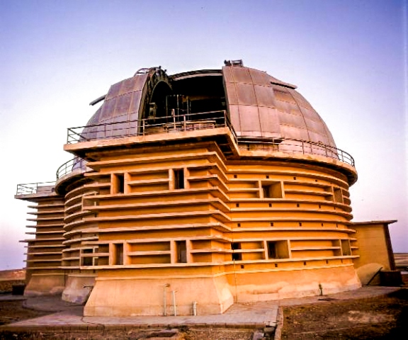
- Keeping dust out will always be a problem for both lunar & North African observatories.
http://www.nriag.sci.eg/?page_id=574 wrote:
<<Kottamia astronomical observatory is the largest telescope in the Arab world, the Middle East and North Africa. The diameter of the 2 ton main mirror is about 74 inches. This telescope is located approximately at 80 km from the center of the capital “Cairo” in the direction of the Suez city over a mount rises 450 meters above sea level. The Observatory established in 1964, as an extension of Helwan observatory, which was established in 1903, one of the oldest research institutes in Egypt and the Middle East.
The observatory building made of double walls; completely isolated from the desert environment surrounding it. The Telescope’s Dome made of double walls of steel. The diameter of the dome is about 19 meters, and weighs more than 100 tons. It revolves around the building upon 26 rods of steel, and the bottom edges of the Telescope’s dome prevent leakage of dust and heat to the interior, and this design makes the temperature of the floor not exceed than 3oC even in the hot days.>>
- Sadly, the Golden Age of Islamic astronomy was over five centuries ago:
https://en.wikipedia.org/wiki/Astronomy_in_the_medieval_Islamic_world wrote:
<<Islamic astronomy comprises the astronomical developments made in the Islamic world, particularly during the Islamic Golden Age (8th–15th centuries), and mostly written in the Arabic language. These developments mostly took place in the Middle East, Central Asia, Al-Andalus, and North Africa, and later in the Far East and India.
1450–1900: The period of stagnation, when the traditional system of astronomy continued to be practised with enthusiasm, but with rapidly decreasing innovation of any major significance.>>
Re: APOD: Earthset from the Lunar Orbiter... (2016 Jan 04)
Posted: Mon Jan 04, 2016 4:53 pm
by neufer
Chris Peterson wrote:APOD Robot wrote:
If you were to sit on the surface of the Moon, you would see the Earth just hang in the sky.
There is nearly half of the lunar surface where you could stand and never see the Earth at all.
- But "APOD Robot" was only talking about "sitting" on the lunar surface.
Re: APOD: Earthset from the Lunar Orbiter... (2016 Jan 04)
Posted: Mon Jan 04, 2016 5:01 pm
by Jim Armstrong
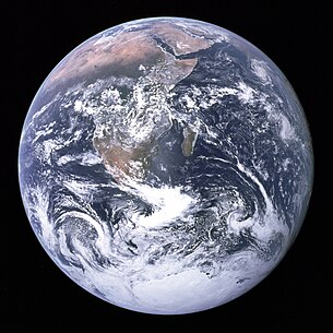
I wonder why that particular part of the Earth's surface seems to be by far the most commonly portrayed.
I have to admit looking for those that show western North America.
It boggles the mind to think of the above-mentioned Moon People living their lives on the far half of their globe only guessing at the things that must never be seen. Except for tourism, of course.
Looking forward to a New Year of APOD!
Re: APOD: Earthset from the Lunar Orbiter... (2016 Jan 04)
Posted: Mon Jan 04, 2016 5:26 pm
by neufer
Jim Armstrong wrote:
I wonder why that particular part of the Earth's surface seems to be by far the most commonly portrayed.
- Everything must be compared to the iconic December 7 Blue Marble photograph over Africa:
https://en.wikipedia.org/wiki/The_Blue_Marble wrote:
<<The Blue Marble is a famous photograph of the Earth, taken on December 7, 1972, by the crew of the Apollo 17 spacecraft, at a distance of about 45,000 kilometers. It is one of the most iconic, and among the most widely distributed images in human history.
Apollo 17 was the first night launch of a U.S. human spaceflight and the last manned lunar mission. No one since has been far enough from Earth to photograph a whole-Earth image such as The Blue Marble.
The photograph was taken about 5 hours and 6 minutes after launch of the Apollo 17 mission, and about 1 hour 54 minutes after the spacecraft left its parking orbit around the Earth, to begin its trajectory to the Moon. The time of Apollo 17's launch, 12:33 a.m. EST, meant that Africa was in daylight during the early hours of the spacecraft's flight. With the December solstice approaching, Antarctica was also illuminated.
Counterculture activists had been among the first to cherish these images as icons of a new global consciousness.
The Apollo 17 image, however, released during a surge in environmental activism during the 1970s, became a symbol of the environmental movement, as a depiction of Earth's frailty, vulnerability, and isolation amid the vast expanse of space.>>
Re: APOD: Earthset from the Lunar Orbiter... (2016 Jan 04)
Posted: Mon Jan 04, 2016 5:47 pm
by geckzilla
The most commonly portrayed part of Earth's surface for me is the American facing side. Real, actual space photos aside, almost every illustration I see shows North and South America. This is probably because I am American and I mostly view American media. South America is visible in this APOD image, but most noticeable is Africa's Sahara. Maybe it is just a lot easier to see the Sahara due to its usually cloudless nature. We certainly don't see many views of the north or south poles given their orientation, so equatorial views are bound to be the most common.
The GOES of XMAS present
Posted: Mon Jan 04, 2016 6:31 pm
by neufer
geckzilla wrote:
The most commonly portrayed part of Earth's surface for me is the American facing side. Real, actual space photos aside, almost every illustration I see shows North and South America. This is probably because I am American and I mostly view American media.
https://en.wikipedia.org/wiki/Geostationary_Operational_Environmental_Satellite wrote:
<<The Geostationary Operational Environmental Satellite system (GOES), operated by the United States' National Environmental Satellite, Data, and Information Service (NESDIS), supports weather forecasting, severe storm tracking, and meteorology research. Spacecraft and ground-based elements of the system work together to provide a continuous stream of environmental data. The National Weather Service (NWS) uses the GOES system for its United States weather monitoring and forecasting operations, and scientific researchers use the data to better understand land, atmosphere, ocean, and climate interactions.
The GOES system uses geosynchronous satellites which—since the launch of SMS-1 in 1974—have been a basic element of U.S. weather monitoring and forecasting.
GOES 13 is designated GOES-East, currently located at 75°W. It was placed in orbit on 24 May 2006, underwent Post-Launch Testing through early 2007, then replaced GOES 12 as GOES-East.>>
Re: APOD: Earthset from the Lunar Orbiter... (2016 Jan 04)
Posted: Mon Jan 04, 2016 7:28 pm
by Beyond
I say we GOES West a bit and get the US of A in the picture. I'm a bit weary of seeing African desert.
Re: APOD: Earthset from the Lunar Orbiter... (2016 Jan 04)
Posted: Mon Jan 04, 2016 7:41 pm
by neufer
Beyond wrote:
I say we GOES West a bit and get the US of A in the picture. I'm a bit weary of seeing African desert.
http://goes.gsfc.nasa.gov/goescolor/goe ... stfull.jpg
http://goes.gsfc.nasa.gov/goescolor/goe ... stfull.jpg
Re: APOD: Earthset from the Lunar Orbiter... (2016 Jan 04)
Posted: Mon Jan 04, 2016 9:11 pm
by ta152h0
we are going to have to invent new superlatives, perhaps mix up some languages together. BTW, I was watching a show called ' The Universe " and this episode featured the big bang, and almost in passing the voice said the Universe was about 156 billion light years across. My brain exploded.
Re: APOD: Earthset from the Lunar Orbiter... (2016 Jan 04)
Posted: Mon Jan 04, 2016 9:16 pm
by tjswift
I hope the APOD elves revise the description to acknowledge lunar libration. It's a much more interesting story and has the added feature of being true. It wouldn't detract from LRO's rapid orbit accomplishments.
Re: APOD: Earthset from the Lunar Orbiter... (2016 Jan 04)
Posted: Mon Jan 04, 2016 9:31 pm
by Guest
A mere 175 million years ago you would have got all of them with one shot...
[imghttp://mail.colonial.net/~hkaiter/Aaa_web_images2012/pangaea.png][/img]
https://en.m.wikipedia.org/wiki/Pangaea
Re: APOD: Earthset from the Lunar Orbiter... (2016 Jan 04)
Posted: Mon Jan 04, 2016 9:33 pm
by Guest
A mere 175 million years ago you would have got all of them with one shot...
 https://en.m.wikipedia.org/wiki/Pangaea
Re: APOD: Earthset from the Lunar Orbiter... (2016 Jan 04)
Posted: Mon Jan 04, 2016 11:27 pm
by Nitpicker
Jeddo wrote:Given the moon's libration
https://en.wikipedia.org/wiki/Libration#Lunar_libration the Earth is not hanging in the same spot of the Moon's sky but tracking an irregular circle – and judging by the significant wobble I would expect this circle to be larger than the Earth's diameter. Consequently, standing on a convenient spot on the Moon's horizon, you _would_ see earthrises and earthsets, though of course not in the opposite directions of the horizon but occurring rather close to each other. One each in 28-odd Earth days.
Indeed you are quite correct. If it were possible for the location of the camera/observer in this APOD, to remain fixed relative to the surface of the Moon, the observer would witness the Earth set fully below the lunar horizon, about 24 hours later (and they'd see a lot of the rest of the surface of the Earth while they observed, in case they had issues with Africa).
Re: APOD: Earthset from the Lunar Orbiter... (2016 Jan 04)
Posted: Tue Jan 05, 2016 12:11 am
by Nitpicker
The "featured image" link suggests that, in the foreground of the APOD, we can see the western portion of (160 km diameter) crater Compton (54-58°N, 100-109°E), including the long shadows from its central peaks. Yet the coordinates given (51.8°N, 124.1°E) do not match Compton, nor could they possibly match the coordinates of the orbiter. The camera would have been pointing just a few degrees South of West to get the Earth in the frame, which means that the orbiter must have been North of 56°N.
Re: APOD: Earthset from the Lunar Orbiter... (2016 Jan 04)
Posted: Tue Jan 05, 2016 12:14 am
by Nitpicker
But what a beautiful image!
Re: APOD: Earthset from the Lunar Orbiter... (2016 Jan 04)
Posted: Tue Jan 05, 2016 3:58 am
by SouthEastAsia
My question would be: what are rough elevations above the lunar surface that the respective hills in the foreground rise? And the elevation of the farthest most peak in this frame??
Thanks in advance and I have to say this must be one of, if not the most remarkable (humbling) and stunning photos ever taken of planet/spaceship Earth from a distant spacecraft. Thank You LRO Team... Simply brilliant.
