Matthew Chojnacki wrote:Two-Color Dunes in Meridiani Terra (ESP_033483_1805) (HiClip)
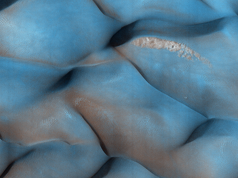
Why are these dunes different colors? Sand on Mars is typically dark in tone, as it commonly derived from volcanic rocks like lava flows. In HiRISE enhanced color, which operates in long infrared wavelengths (beyond what the human eye can detect), surfaces like these dune crests are dark blue to purple. Sand comes in sizes that are ideal for surface transport by the wind, where sand “hops” along forming bedforms, like these dunes after large amounts of time.
The lighter toned “tan” or “reddish” surfaces are indeed composed of a different material, but not as sand sized particle that makes up the bulk of these dunes. Rather, the light-toned smooth surfaces that dominate the lower, flatter areas of the dunes are a thin coating of global dust. Dust on Mars is composed of a variety of materials, including oxidized iron, like rust.
For a given wind gust, speeds are not constant at different heights. Rather, wind speeds are greater with height above the ground and wind energy drops to nearly zero at the surface. Dust persists on flatter dune areas, because wind energy there has not been sufficient to remove it, whereas “dust free” higher-lying dune crests are subject to more intense winds, which ultimately conspire to make the appearance of two-color dunes.
Nicole Baugh wrote:Slumping Terraces on a Crater Wall (ESP_035702_2270) (HiClip)
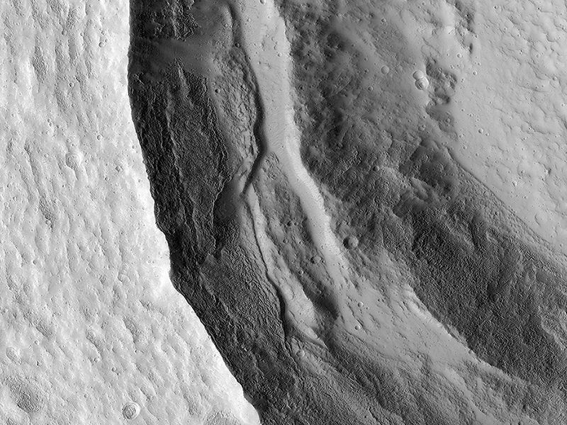
This image shows the western rim of a well-preserved 8.5-kilometer (about 5 miles) diameter impact crater.
The wall features a slumped terrace that extends all the way around the crater diameter (the adjacent image shows the rest of the terrace). This slumped terrace, a result of the crater formation process, gives the crater a concentric ringed appearance.
Terraces are an expected feature in Martian craters of this size or larger, as the material strength of the surface is overcome by the force of all-of-the-sudden-missing mass. Blocks of rock slump down the steep crater walls and slide inward (by contrast, terraces in smaller craters are often the product of an impact of an object into a surface with layers of differing material strength).
Ramy El-Maarry wrote:A Heart in Ascraeus Mons (ESP_035807_1885) (HiClip)
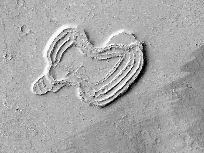
What is this strange-looking feature? HiRISE scientists first noticed it in images from the Context Camera and acquired this picture to investigate more closely.
The feature indeed does look like a heart. It is located south of Ascraeus Mons, which is a large volcano within the Tharsis volcanic plateau, so it is extremely likely that this feature was formed by a volcanic process. The feature rises above the surrounding terrain and we can see concentric ridges on its top. Perhaps this feature is an ancient vent structure (an opening in the ground from which volcanic lava emerges) that has been more resistant to erosion than the surrounding area, so that it resembles “inverted” terrains.
Topographic inversion or inverted terrain often occurs when low areas of a landscape become filled with lava or sediments that harden into materials which are more resistant to erosion than the materials that surround them. Differential erosion then removes the less resistant surrounding material, leaving behind the younger resistant material which may then appear as a ridge where previously there was a valley, or in our case, a butte, where there was once a pit or depression.
Additional imaging of the feature to create a stereo and a digital terrain model may help in further assessing the structure by making accurate measurement of its height and the steepness of its slopes.
Matt Chojnacki wrote:Opportunity Rover's Winter Work at Murray Ridge (ESP_035909_1775) (HiClip)
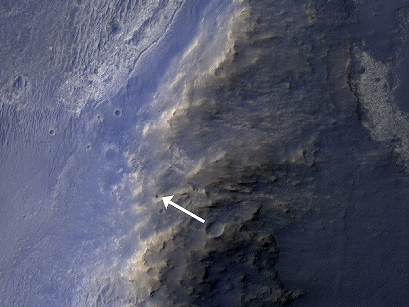
This HiRISE image of the Opportunity rover was acquired as a coordinated “ride-along” observation with the CRISM instrument, also onboard the Mars Reconnaissance Orbiter. The CRISM instrument is a spectrometer that views the surface in many wavelengths beyond what the human eye can detect, allowing for mineral identification of the Martian surface.
HiRISE images can be used to construct digital terrain models (or DTM), like the one of Endeavour Crater’s western rim, which provides high-resolution topography for landing site support. This southward prospective view was built using that DTM.
The use of CRISM mineralogy, along with topography and fine-scale images from HiRISE will aid in Opportunity's investigation into the geologic history of the Murray Ridge of Endeavour Crater.
Credit: NASA/JPL/University of Arizona
<< Previous HiRISE Update


