APOD: Earths Richat Structure (2013 May 19)

Comments and questions about the APOD on the main view screen.
User avatar
APOD Robot
Otto Posterman
Posts: 5589
Joined: Fri Dec 04, 2009 3:27 am
Contact:

APOD: Earths Richat Structure (2013 May 19)

Post by APOD Robot » Sun May 19, 2013 4:06 am

Image Earths Richat Structure

Explanation: What on Earth is that? The Richat Structure in the Sahara Desert of Mauritania is easily visible from space because it is nearly 50 kilometers across. Once thought to be an impact crater, the Richat Structure's flat middle and lack of shock-altered rock indicates otherwise. The possibility that the Richat Structure was formed by a volcanic eruption also seems improbable because of the lack of a dome of igneous or volcanic rock. Rather, the layered sedimentary rock of the Richat structure is now thought by many to have been caused by uplifted rock sculpted by erosion. The above image was captured by the ASTER instruments onboard the orbiting orbiting Terra satellite. Why the Richat Structure is nearly circular remains a mystery.

<< Previous APOD This Day in APOD Next APOD >>
[/b]

Boomer12k
:---[===] *
Posts: 2691
Joined: Sun Apr 22, 2007 12:07 am

Re: APOD: Earths Richat Structure (2013 May 19)

Post by Boomer12k » Sun May 19, 2013 5:20 am

Very interesting pattern for erosion. Very interesting phenomena, striking in appearance, with its own beauty....at first I thought I was looking at an Open Pit Mining Operation...looks like there are waves and water...like an ocean....yet is out in the desert...fascinating....

:---[===] *

Moosewhisper

Re: APOD: Earths Richat Structure (2013 May 19)

Post by Moosewhisper » Sun May 19, 2013 5:30 am

I believe this to be an Impact from a Very dense and small object travelling at a very high speed, much like a bullet, at a slight angle to deep within our world, just a first impression of corse. Mike Burdic~Moosewhisper

SouthEastAsia

Re: APOD: Earths Richat Structure (2013 May 19)

Post by SouthEastAsia » Sun May 19, 2013 6:38 am

Is there an estimated age for this 'Structure'? 1 Billion years? Older? 100 million years old? That would be an interesting point too.

Very fascinating indeed.

FLPhotoCatcher
Science Officer
Posts: 247
Joined: Wed Jul 18, 2012 6:51 am

Re: APOD: Earths Richat Structure (2013 May 19)

Post by FLPhotoCatcher » Sun May 19, 2013 6:39 am

I would say that it was uplifted by a pocket of magma that never broke the surface as a volcano. Then it eroded significantly before it subsided, thus explaining the lower-than-surrounding-terrain ring around slightly higher center areas.

nstahl
Science Officer
Posts: 233
Joined: Mon Nov 29, 2004 4:08 am

Re: APOD: Earths Richat Structure (2013 May 19)

Post by nstahl » Sun May 19, 2013 9:40 am

An enigma wrapped in sand.

User avatar
MargaritaMc
Look to the Evenstar
Posts: 1836
Joined: Wed Jan 09, 2013 10:14 pm
Location: 28°16'7"N 16°36'20"W

Re: APOD: Earths Richat Structure (2013 May 19)

Post by MargaritaMc » Sun May 19, 2013 10:06 am

SouthEastAsia wrote:Is there an estimated age for this 'Structure'? 1 Billion years? Older? 100 million years old? That would be an interesting point too.

Very fascinating indeed.
http://en.wikipedia.org/wiki/Richat_Structure
The sedimentary rock exposed in this dome range in age from Late Proterozoic within the center of the dome to Ordovician sandstone around its edges.
Still Wikipedia:
The Proterozoic Eon extended from 2,500 Ma to 542.0±1.0 Ma (million years ago),

The Ordovician covers the time between 485.4 ± 1.9 to 443.4 ± 1.5 million years.

Margarita
"In those rare moments of total quiet with a dark sky, I again feel the awe that struck me as a child. The feeling is utterly overwhelming as my mind races out across the stars. I feel peaceful and serene."
&mdash; Dr Debra M. Elmegreen, Fellow of the AAAS

User avatar
Beyond
500 Gigaderps
Posts: 6889
Joined: Tue Aug 04, 2009 11:09 am
Location: BEYONDER LAND

Re: APOD: Earths Richat Structure (2013 May 19)

Post by Beyond » Sun May 19, 2013 10:13 am

Non-man made non-crop circles.

Movie title: IT escaped from with-in. (But is IT coming back?)

Movie title: Journey from the center of the earth.

Perhaps it is where God stuck his finger in, to check and see if the earth was fully baked?

Or perhaps something more mundane, like what Wikipedia says in the first link.

Richat Structure


From Wikipedia, the free encyclopedia


Jump to: navigation, search


A topographic reconstruction (scaled 6:1 on the vertical axis) from satellite photos. False coloring as follows: bedrock=brown, sand=yellow/white, vegetation=green, salty sediments=blue.


Satellite picture of the Richat Structure.
The Richat Structure, also known as the Eye of the Sahara and Guelb er Richat, is a prominent circular feature in the Sahara desert of west–central Mauritania near Ouadane. This structure is a deeply eroded, slightly elliptical, 40 km in diameter, dome. The sedimentary rock exposed in this dome range in age from Late Proterozoic within the center of the dome to Ordovician sandstone around its edges. The sedimentary rocks comprising this structure dip outward at 10°-20°. Differential erosion of resistant layers of quartzite has created high-relief circular cuestas. Its center consists of a siliceous breccia covering an area that is at least 3 km in diameter.[1][2][3]

Exposed within the interior of the Richat Structure are a variety of intrusive and extrusive igneous rocks. They include rhyolitic volcanic rocks, gabbros, carbonatites and kimberlites. The rhyolitic rocks consist of lava flows and hydrothermally altered tuffaceous rocks that are part of two distinct eruptive centers, which are interpreted to be the eroded remains of two maars. According to field mapping and aeromagnetic data, the gabbroic rocks form two concentric ring dikes. The inner ring dike is about 20 m in width and lies about 3 km from the center of Richat Structure. The outer ring dike is about 50 m in width and lies about 7 to 8 km from the center of this structure. Thirty-two carbonatite dikes and sills have been mapped within the Richat Structure. The dikes are generally about 300 m long and typically 1 to 4 m wide. They consist of massive carbonatites that are mostly devoid of vesicles. The carbonatite rocks have been dated as having cooled between 94 to 104 million years ago. A kimberlitic plug and several sills have been found within the northern part of the Richat Structure. The kimberlite plug has been dated being about 99 million years old. These intrusive igneous rocks are interpreted as indicating the presence of a large alkaline igneous intrusion that currently underlies the Richat Structure and created it by uplifting the overlying rock.[1][2][3][4]

Spectacular hydrothermal features are a part of the Richat Structure. They include the extensive hydrothermal alteration of rhyolites and gabbros and a central megabreccia created by hydrothermal dissolution and collapse. The siliceous megabreccia is at least 40 m thick in its center to only a few meters thick along its edges. The breccia consists of fragments of white to dark gray cherty material, quartz-rich sandstone, diagenetic cherty nodules, and stromatolitic limestone and is intensively silicified. The hydrothermal alteration, which created this breccia, has been dated to have occurred about 98.2 ± 2.6 million years ago using the 40Ar/39Ar method.[1][2][3]

Initially interpreted as an asteroid impact structure because of its high degree of circularity, it is now argued to be a highly symmetrical and deeply eroded geologic dome. Despite extensive field and laboratory studies, geologists have found a lack of any credible evidence for shock metamorphism or any type of deformation indicative of a hypervelocity extraterrestrial impact.[5] While coesite, an indicator of shock metamorphism, had initially been reported as being present in rocks samples collected from the Richat Structure, further analysis of rock samples concluded that barite had been misidentified as coesite.[6] In addition, the Richat Structure lacks the annular depression that characterizes large extraterrestrial impact structures of this size. Also, it is quite different from large extraterrestrial impact structures in that the sedimentary strata comprising this structure is remarkably intact and "orderly" and lacking in overturned, steeply dipping strata or disoriented blocks.[1][2] A more recent multianalytical study on the Richat megabreccias concluded that carbonates within the silica-rich megabreccias were created by low-temperature hydrothermal waters, and that the structure requires special protection and further investigation of its origin.[7]

The second Richat link has 6 pictures of it.
To find the Truth, you must go Beyond.

User avatar
JohnD
Tea Time, Guv! Cheerio!
Posts: 1593
Joined: Wed Feb 16, 2005 2:11 pm
Location: Lancaster, England

Re: APOD: Earths Richat Structure (2013 May 19)

Post by JohnD » Sun May 19, 2013 11:01 am

Is there a magnetic anomaly?
Has no one dug down in the middle of it?

http://www.iconarchive.com/show/2001-sp ... -icon.html

John

randyrls

Re: APOD: Earths Richat Structure (2013 May 19)

Post by randyrls » Sun May 19, 2013 12:41 pm

I one saw a movie concerning the K-T Asteroid impact. It showed the impact shock waves as radiatng lines on the surface of the earth. I wondered what happened to those pressure waves when they converged at the antipodes of the impact? Would it look like this? While the rocks of the structure are of an older age, is there anyway to determine the age of formation of the structure itself?

Kap

Re: APOD: Earths Richat Structure (2013 May 19)

Post by Kap » Sun May 19, 2013 12:55 pm

Being at the lead edge of a large land depression, it looks like it might be an ancient drainage area where a giant whirlpool once formed.

tekic545
Ensign
Posts: 34
Joined: Sun Apr 06, 2008 1:20 pm
Location: Ossipee NH USA

Re: APOD: Earths Richat Structure (2013 May 19)

Post by tekic545 » Sun May 19, 2013 1:00 pm

Visually dramatic, but not so mysterious in origin. As Wkipedia notes, there is a long history of igneous intrusion in the area. A large igneous bulge almost certainly caused the uplift. Erosion of differentially resistant rock layers (hard quartzite vs. softer sediments) accounts for the ringed appearance of the uplifted bulge.

Bob

Dr. Work
Asternaut
Posts: 7
Joined: Sun May 19, 2013 1:33 pm

Spoiler alert!

Post by Dr. Work » Sun May 19, 2013 1:40 pm

It's clearly the starship Enterprise, specifically the saucer section. The ship crashes to Earth in the latest movie, Into Darkness. At least, that is what the previews suggest, as I haven't watched it yet ;-).

User avatar
neufer
Vacationer at Tralfamadore
Posts: 18805
Joined: Mon Jan 21, 2008 1:57 pm
Location: Alexandria, Virginia

Reguibat Craton gets black eye from being WAC'd

Post by neufer » Sun May 19, 2013 2:53 pm

https://en.wikipedia.org/wiki/West_African_craton wrote:
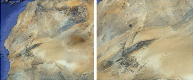
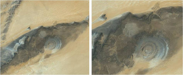
Zeroing in on the Richat Structure
Click to view full size image 1 or image 2

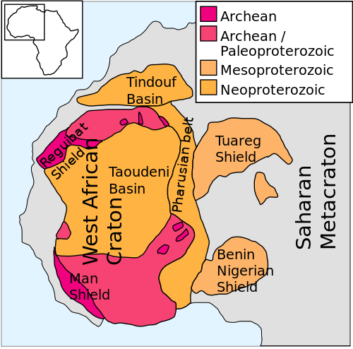
<<The West African Craton is one of the five large masses, or cratons, of the Precambrian basement rock of Africa that make up the African Plate, the others being the Kalahari craton, Congo craton, Saharan Metacraton and Tanzania Craton. These land masses came together in the late Precambrian and early Palaeozoic eras to form the African continent. At one time, volcanic action around the rim of the craton may have contributed to a major global warming event.

The craton appears to have formed when three Archean cratons fused: Leo-Man-Ghana, Taoudeni and Reguibat. The first two docked around 2,100 Ma (million years ago), and the Reguibat Craton docked with the craton around 2,000 Ma. The roots of the combined craton extend to a depth of over 300 km in the sub-continental lithospheric mantle.

The Earth formed about 4.6 billion years ago. As it cooled the lithosphere, consisting of the crust and the rigid uppermost part of the mantle solidified. The lithosphere rides on the asthenosphere, which is also solid but can flow like a liquid on geological time scales. The lithosphere is broken up into tectonic plates, which slowly move in relation to one another at speeds of 50–100 mm annually, colliding, combining into continents, splitting and drifting apart to form new continental configurations.

It is difficult to reconstruct the early wanderings of the West African Craton, but around 1,100 million years ago it seems to have been one of the cratons that came together to form Rodinia, a supercontinent. At that time, the Congo Craton lay to the west of the Amazonia Craton, and the West African Craton lay to the south of them (rotated about 180°, they retain this relative configuration.) Around 750 million years ago Rodinia rifted apart into three continents: Proto-Laurasia, the Congo craton and Proto-Gondwana. The West African Craton may then have combined with other cratons to form Pannotia, a hypothetical supercontinent that existed from the Pan-African orogeny about 600 million years ago to the end of the Precambrian about 540 million years ago. Later it became part of Gondwana, and later still part of Pangaea, the supercontinent that existed during the Paleozoic and Mesozoic eras about 250 million years ago, before North and South America separated from Eurasia and Africa and the continents started to drift towards their current configuration.
Art Neuendorffer

ta152h0
Schooled
Posts: 1399
Joined: Mon Aug 29, 2005 12:46 am
Location: Auburn, Washington, USA

Re: APOD: Earths Richat Structure (2013 May 19)

Post by ta152h0 » Sun May 19, 2013 3:39 pm

Ancient, very ancient gigantic mega tornado touching down and never happening again.....maybe....
Wolf Kotenberg

Guest

Re: APOD: Earths Richat Structure (2013 May 19)

Post by Guest » Sun May 19, 2013 3:40 pm

Those are the ages of the rock layers, not the structure. Something has to have uplifted the rocks, and because the structure contains circular volcanic intrusions, that something must be a larger parent intrusion below. The volcanic rocks are about 100 million years old. So that is the age of the structure. It is basically a laccolith.
MargaritaMc wrote:
SouthEastAsia wrote:Is there an estimated age for this 'Structure'? 1 Billion years? Older? 100 million years old? That would be an interesting point too.

Very fascinating indeed.
http://en.wikipedia.org/wiki/Richat_Structure
The sedimentary rock exposed in this dome range in age from Late Proterozoic within the center of the dome to Ordovician sandstone around its edges.
Still Wikipedia:
The Proterozoic Eon extended from 2,500 Ma to 542.0±1.0 Ma (million years ago),

The Ordovician covers the time between 485.4 ± 1.9 to 443.4 ± 1.5 million years.

Margarita

nigel

Re: APOD: Earths Richat Structure (2013 May 19)

Post by nigel » Sun May 19, 2013 3:51 pm

It is misleading for APOD to discount the presence of volcanic rocks. The Wikipedia page explains them well. There are both extrusive and intrusive volcanic rocks, and they have a pretty clear geometric relationship to the structure. There must be a larger parent intrusion below that was responsible for the uplift. No other explanation seems possible. This would firmly date the structure at around 100 million years old (the dates on the volcanic rocks range from 104 to 99 m.y.).

I wouldn't say that the structure is all that mysterious. Spectacular, yes, mysterious, no.

User avatar
Psnarf
Science Officer
Posts: 325
Joined: Fri Feb 26, 2010 6:19 pm

Re: APOD: Earths Richat Structure (2013 May 19)

Post by Psnarf » Sun May 19, 2013 4:03 pm

:wink: Looks like each of the open-pit copper/gold mines in Arizona. Might be the site of the Slate Rock and Gravel Company where Fred Fintstone operated a bronto-crane.

ta152h0
Schooled
Posts: 1399
Joined: Mon Aug 29, 2005 12:46 am
Location: Auburn, Washington, USA

Re: APOD: Earths Richat Structure (2013 May 19)

Post by ta152h0 » Sun May 19, 2013 4:10 pm

I like that..Fred Flinstone
Wolf Kotenberg

Lordcat Darkstar
Ensign
Posts: 37
Joined: Sat Mar 31, 2012 2:49 pm

Re: APOD: Earths Richat Structure (2013 May 19)

Post by Lordcat Darkstar » Sun May 19, 2013 4:33 pm

I can explain it in one word... ALIENS!!! :shock: Just kidding :lol2: It is a very cool structure. Sadly all I have is boring old clay where I live. All of the interesting rocks and dead dinos are about 20 feet down. :? I do have lots of coal under my place though, so if Texas ever gets cold ill be fine. :mrgreen:

User avatar
neufer
Vacationer at Tralfamadore
Posts: 18805
Joined: Mon Jan 21, 2008 1:57 pm
Location: Alexandria, Virginia

Re: APOD: Earths Richat Structure (2013 May 19)

Post by neufer » Sun May 19, 2013 4:36 pm

Lordcat Darkstar wrote:
It is a very cool structure. Sadly all I have is boring old clay where I live.
http://asterisk.apod.com/viewtopic.php? ... ay#p199471
Art Neuendorffer

User avatar
neufer
Vacationer at Tralfamadore
Posts: 18805
Joined: Mon Jan 21, 2008 1:57 pm
Location: Alexandria, Virginia

Re: APOD: Earths Richat Structure (2013 May 19)

Post by neufer » Sun May 19, 2013 4:46 pm


Psnarf wrote:
Might be the site of the Slate Rock and Gravel Company
where Fred Fintstone operated a bronto-crane.
https://en.wikipedia.org/wiki/Apatosaurus wrote:
<<Apatosaurus, also known as the Brontosaurus, is a genus of sauropod dinosaur that lived from about 154 to 150 million years ago, during the Jurassic Period.>>
nigel wrote:
It is misleading for APOD to discount the presence of volcanic rocks. This would firmly date the [Richat Structure] at around 100 million years old.
Mr. Slate: Fred's hot tempered boss at the stone quarry. Though he is friends with Fred and Barney, he is often not impressed with Fred's antics at the quarry, and has fired him on many occasions, only to give him his job back at the end.

A running gag is Mr. Slate's ever-changing first name, which has been presented as Sylvester, Nate, Oscar and George.
Art Neuendorffer

fastartcee
Asternaut
Posts: 7
Joined: Wed Jan 02, 2013 4:41 pm

Re: APOD: Earths Richat Structure (2013 May 19)

Post by fastartcee » Sun May 19, 2013 6:25 pm

Come on, AstroBuffs ...it's obviously a bull's-eye target built by Klingons. They (ugly, but very advanced) accomplished this by burying a powerful anti-gravity device at a depth of 90 +/- 3 kilometres, knowing that in a few million Earth years natural erosive processes would slowly create the desired structure.

Nothing to worry about here, unless they commence testing their new hyperphoton-torpedo guidance system for accuracy.

Why Earth? ...Seems they're still pissed off with Kirk.

PS. I wouldn't buy any recreation property within 500 km of the centre of the Richat structure; that would put you within three sigma of the expected torpedo impact point. (Yep, even from 700 light years the Klingon military-industrial complex is that good!)

User avatar
neufer
Vacationer at Tralfamadore
Posts: 18805
Joined: Mon Jan 21, 2008 1:57 pm
Location: Alexandria, Virginia

So Long, and Thanks for All the Fish.

Post by neufer » Sun May 19, 2013 7:34 pm

fastartcee wrote:
Image
Come on, AstroBuffs ...it's obviously a bull's-eye target built by Klingons. They (ugly, but very advanced) accomplished this by burying a powerful anti-gravity device at a depth of 90 +/- 3 kilometres, knowing that in a few million Earth years natural erosive processes would slowly create the desired structure. Nothing to worry about here, unless they commence testing their new hyperphoton-torpedo guidance system for accuracy.

PS. I wouldn't buy any recreation property within 500 km of the centre of the Richat structure; that would put you within three sigma of the expected torpedo impact point. (Yep, even from 700 light years the Klingon military-industrial complex is that good!)
http://www.digitaljournal.com/article/350414 wrote:
Image
Navy dolphins find 19th century Howell torpedo off Calif. coast
By JohnThomas Didymus, May 19, 2013

<<A US Navy dolphin has discovered a 19th century torpedo in deep water off the coast of San Diego, California, during an underwater mine detection training exercise. The 11-foot brass torpedo known as the Howell was built and deployed about 130 years ago. The find is of great significance to military historians because it was one of the first self-propelled torpedoes ever built.

The US military has trained dolphins for underwater operations at the Point Loma facility since the 1960s. Dolphins have a sophisticated bisonar system that engineers still do not fully understand. 80 dolphins and 40 sea lions are being trained for mine detection, mine clearing and swimmer protection. The animals are trained to dive and locate objects with the shapes of known mines. When the dolphin finds an object that could be a mine it surfaces and touches the front of the boat with its snout, but if it finds nothing it touches the back. A trained dolphin called Ten surfaced unexpectedly and touched the front of the boat. Mike Rothe, who heads the marine mammal program, said: "It went positive in a place we didn't expect." Another dolphin named Spetz also gave a positive signal a week later. Spetz was ordered to take a marker to the object it discovered. Navy divers located the object and found it was an old inert torpedo broken in two pieces with "USN No.24" stamped on one of the pieces. Harris said: "It was apparent in the first 15 minutes that this was something that was significant and really old. Realizing that we were the first people to touch it or be around it in over 125 years was really exciting."

According to the Los Angeles Times, the torpedo was made of brass and designed to be launched from above water or underwater in torpedo tubes. It was 11 feet long and driven by a 132-pound flywheel that was spun to 10,000 rpm before it was launched. It had a range of 400 yards and a speed of 25 knots and a warhead filled with 100 pounds of gun cotton. Only 50 were made between 1870 and 1889 by a Rhode Island company, before another company began producing more advanced models. It was used by the US Navy until it was replaced by the Whitehead in 1898. Until the the bottlenose dolphins found the torpedo, only one specimen was known to exist and it was on display at the Naval Undersea Museum in Keyport, Washington. Duryee said: "There were only 50 Howell torpedoes made, and we discovered one of the two ever found." The US Navy deployed the Howell torpedo between 1870 and 1889. DVIDS reports that the torpedo, developed by Lt. Cmdr. John A. Howell, between 1870 and 1889, was the first capable of following a track without leaving a wake as it homes in on a target. The torpedoes were considered important breakthrough in military technology at the time. Harris, said: “It was the first torpedo that could be released into the ocean and follow a track. Considering that it was made before electricity was provided to U.S. households, it was pretty sophisticated for its time.">>
Art Neuendorffer

Guest

Re: APOD: Earths Richat Structure (2013 May 19)

Post by Guest » Sun May 19, 2013 11:53 pm

It's clearly a flying saucer landing site.

Post Reply