Page 1 of 1
Celestial coordinate system ?
Posted: Sat May 26, 2012 11:44 pm
by Moonlady
I couldnt find anything about celestial coordinate system here.
I would like to have examples on how these are used. I know the definitions but I dont know if I understood them well. (on Wiki)
I was on a little field trip yesterday evening/night and I saw Venus in the west above horizon, but how do I express it with degree etc.
It is the same with MArs, it is well to be seen in south-west,
and Saturn is in the south very well to spot.
Well at least were I live.
You get my problem, I am clueless because I am amateur, I wish a tutorial as a vid. Is it possible that Prof Nemiroff would make one? That would be great!
Thanks a lot!!!
Re: Celestial coordinate system ?
Posted: Sun May 27, 2012 12:32 am
by Chris Peterson
Moonlady wrote:I couldnt find anything about celestial coordinate system here.
I would like to have examples on how these are used. I know the definitions but I dont know if I understood them well. (on Wiki)
There are two systems in common use from the surface of the Earth, both analogous to latitude and longitude.
The easiest to understand is the horizon or altitude-azimuth (altaz) system. The is an observer-centered system, with the azimuth axis being the compass angle (usually with 0° to the north, and the value increasing eastwards), and the altitude axis being the angle in degrees above the horizon. Azimuth ranges from 0° to 360°, and altitude from 0° to 90° (the zenith). This is useful for defining where something will be at a specific time, like where the Moon will rise, or where something is right now in the sky.
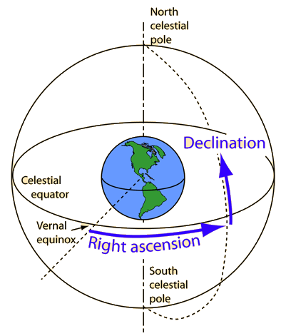
The most common celestial coordinate system is the equatorial system. This also defines the position of an object using two coordinates. Imagine you drew all the stars on a globe. The right ascension axis corresponds to longitude, and like longitude has a 360° range. The declination axis corresponds to latitude, and has a 180° range (typically +90° to -90°). This globe is aligned so that its poles intersect a line drawn through the Earth's poles. Thus, if you're standing on the North Pole, the zenith (straight overhead) has a declination of +90. If you're on the equator, the declination of the zenith is 0°. And at the South Pole, the zenith declination is -90°. Right ascension counts 0° from an arbitrary point (just like longitude arbitrarily starts at Greenwich). Because the Earth rotates through 360° in about 24 hours, RA has historically been measured in hours, not degrees. One hour of right ascension is 15°- the amount the Earth turns in an hour. However, it is increasingly common to see RA specified directly in degrees.
Any relatively fixed object in the sky (like a star) has a given pair of coordinates. By knowing those, and knowing the time and date on the Earth, you can calculate where in the sky that object can be found. The important idea is recognizing that your position on the Earth is like the hour hand of a 24-hour clock. The stars are like the numbers on the clock dial- they stay the same, but you are moving so you always see their apparent position changing.
Re: Celestial coordinate system ?
Posted: Sun May 27, 2012 2:40 am
by Beyond
Chris, are you sure that a 24 hr clock is used instead of a 12 hr face? That's a lot of numbers squeezed in. It would seem to be hard for many to be able to define a position that small without useing an instrument of some kind.
Re: Celestial coordinate system ?
Posted: Sun May 27, 2012 3:10 am
by Chris Peterson
Beyond wrote:Chris, are you sure that a 24 hr clock is used instead of a 12 hr face? That's a lot of numbers squeezed in. It would seem to be hard for many to be able to define a position that small without useing an instrument of some kind.
We turn once around every 24 hours (actually, every 23 hours, 56 minutes, 4.1 seconds).
Re: Celestial coordinate system ?
Posted: Sun May 27, 2012 3:57 am
by Beyond
Heh, seeing as how i'm not even an amateur, i can just ignore the whole thing


Re: Celestial coordinate system ?
Posted: Mon May 28, 2012 2:10 am
by Moonlady
Beyond wrote:Chris, are you sure that a 24 hr clock is used instead of a 12 hr face? That's a lot of numbers squeezed in. It would seem to be hard for many to be able to define a position that small without useing an instrument of some kind.
Beyond, stop annoying my teacher here

::kicks u::
Thanks Chris, I need babysteps, I start with the easier way , the altaz system.
I have a beautiful Apod and I have marked it:
In this example a random clueless comrade watches the Moon and Venus.
The position of the Moon would be near horizon in the southwest:
~5°altitude and ~ 230° azimuth.
The position of Venus is ~65° altitude and ~260°azimuth.
Is this ok?
Re: Celestial coordinate system ?
Posted: Mon May 28, 2012 4:02 am
by Chris Peterson
Moonlady wrote:I have a beautiful Apod and I have marked it:
In this example a random clueless comrade watches the Moon and Venus.
The position of the Moon would be near horizon in the southwest:
~5°altitude and ~ 230° azimuth.
The position of Venus is ~65° altitude and ~260°azimuth.
Is this ok?
The zenith is way out of the frame at the top. Since the angular diameter of the Moon is about 0.5°, the range of altitude seen in this image is only two or three degrees. We don't really know where the true horizon is, but certainly the altitude of the Moon is no more than a few degrees. But the altitude of Venus is only about another half-degree above that. 230° azimuth for the Moon and 260° azimuth for Venus look about right if you assume the annotation accurately indicates southwest and west... but it does not. Those points are separated by 45°, but the size of the Moon provides an absolute scale, so it's clear that on the actual image those labels are separated by only three or four degrees.
Re: Celestial coordinate system ?
Posted: Mon May 28, 2012 4:16 pm
by ritwik
Re: Celestial coordinate system ?
Posted: Mon May 28, 2012 6:50 pm
by TNT
How would you put these measurements into standard notation (°, ', ")? Or are certain symbols equatorial and altazimuthal?
Re: Celestial coordinate system ?
Posted: Mon May 28, 2012 7:29 pm
by Chris Peterson
TNT wrote:How would you put these measurements into standard notation (°, ', ")? Or are certain symbols equatorial and altazimuthal?
Declination is always expressed in degrees, with the sign shown. It may be in dms notation (+30° 15' 45" / +30d 15m 45s), in degrees with decimal minutes (+30° 15.75'), or decimal degrees (+30.2625°). RA may be expressed in degrees as well (222.833°), using the same notational forms as declination (but with no sign, since it's always positive), or in hour/minute/second format (14h 51m 20s), or even in decimal hours.
Altitude and azimuth are always expressed in degrees, either dms or one of the decimal variations given above. Both values are normally positive, so you don't typically use a sign. There are special cases of altitude where you might use a negative sign, as when describing the altaz position of the Sun after it has set.
Re: Celestial coordinate system ?
Posted: Mon May 28, 2012 8:52 pm
by Moonlady
Chris Peterson wrote:Moonlady wrote:I have a beautiful Apod and I have marked it:
In this example a random clueless comrade watches the Moon and Venus.
The position of the Moon would be near horizon in the southwest:
~5°altitude and ~ 230° azimuth.
The position of Venus is ~65° altitude and ~260°azimuth.
Is this ok?
The zenith is way out of the frame at the top. Since the angular diameter of the Moon is about 0.5°, the range of altitude seen in this image is only two or three degrees. We don't really know where the true horizon is, but certainly the altitude of the Moon is no more than a few degrees. But the altitude of Venus is only about another half-degree above that. 230° azimuth for the Moon and 260° azimuth for Venus look about right if you assume the annotation accurately indicates southwest and west... but it does not. Those points are separated by 45°, but the size of the Moon provides an absolute scale, so it's clear that on the actual image those labels are separated by only three or four degrees.
Angular diameter of the moon being 0.5° is very helpful, thanks!!!
I made a correction, I hope I understand what you teach me!
Moon: altitude: ~3° azimuth: ~230°
Venus: altitude: ~3.5° azimuth ~232 °
Is this better?
Re: Celestial coordinate system ?
Posted: Mon May 28, 2012 10:59 pm
by Chris Peterson
Moonlady wrote:Angular diameter of the moon being 0.5° is very helpful, thanks!!!
I made a correction, I hope I understand what you teach me!
Moon: altitude: ~3° azimuth: ~230°
Venus: altitude: ~3.5° azimuth ~232 °
Is this better?
Those are about the numbers I'd estimate from the available information.
Re: Celestial coordinate system ?
Posted: Tue May 29, 2012 4:56 am
by Moonlady
Example 3:
What happens to azimuth, when I look up above my head?
Altitude 90°
Azimuth 0° = no data?
I made a picture.
Thanks.
Re: Celestial coordinate system ?
Posted: Tue May 29, 2012 2:03 pm
by Chris Peterson
Moonlady wrote:What happens to azimuth, when I look up above my head?
In altaz coordinates, the azimuth of the zenith is undefined. Mathematically, it's a singularity, and altaz telescope mounts have difficulties tracking through the zenith. In equatorial coordinates, the right ascension of the poles is undefined, for the same reason, and polar telescope mounts have tracking problems very close to the poles.
Both cases are equivalent to asking what your longitude is when standing at the North Pole. The answer is, it's undefined.
Re: Celestial coordinate system ?
Posted: Wed May 30, 2012 1:23 am
by Moonlady
Chris Peterson wrote:Moonlady wrote:What happens to azimuth, when I look up above my head?
In altaz coordinates, the azimuth of the zenith is undefined. Mathematically, it's a singularity, and altaz telescope mounts have difficulties tracking through the zenith. In equatorial coordinates, the right ascension of the poles is undefined, for the same reason, and polar telescope mounts have tracking problems very close to the poles.
Both cases are equivalent to asking what your longitude is when standing at the North Pole. The answer is, it's undefined.
How do I express undefined as a symbol in astronomy? Or can I write zero 0?
I didnt know that telescope mounts have such differences about trecking, good to know.
You wrote:
Right ascension counts 0° from an arbitrary point (just like longitude arbitrarily starts at Greenwich). Because the Earth rotates through 360° in about 24 hours, RA has historically been measured in hours, not degrees. One hour of right ascension is 15°- the amount the Earth turns in an hour. However, it is increasingly common to see RA specified directly in degrees.
Right ascension counts 0° from arbitrary point: Where do I start counting?
Which facts do I have to know to calculate RA of an object in the night sky?
Thanks.
Re: Celestial coordinate system ?
Posted: Wed May 30, 2012 2:40 am
by Chris Peterson
Moonlady wrote:How do I express undefined as a symbol in astronomy? Or can I write zero 0?
You can't write zero- that is a defined value. There is no standard symbol for undefined. Normally you just leave off the other coordinate. When something is at the zenith, you say it's at the zenith, or you say its altitude is 90°. Since the azimuth is meaningless, you need not mention it at all.
You wrote:
Chris Peterson wrote:Right ascension counts 0° from an arbitrary point (just like longitude arbitrarily starts at Greenwich). Because the Earth rotates through 360° in about 24 hours, RA has historically been measured in hours, not degrees. One hour of right ascension is 15°- the amount the Earth turns in an hour. However, it is increasingly common to see RA specified directly in degrees.
Right ascension counts 0° from arbitrary point: Where do I start counting?
0° RA is the vernal equinox: the longitudinal line that the Sun is on just as it crosses the celestial equator on the March equinox.
Which facts do I have to know to calculate RA of an object in the night sky?
Well, typically you know the RA, and want to figure out where to find that point in the sky. This is a moderately messy calculation that uses the Julian date, the time, and your longitude. Few people bother with the calculation given all the local and web-based sky chart applications that are out there. If you're really interested in the details, read the Wikipedia articles on "hour angle" and "sidereal time" and then come back with your questions.
Re: Celestial coordinate system ?
Posted: Wed May 30, 2012 5:24 am
by TNT
Chris Peterson wrote:altaz telescope mounts have difficulties tracking through the zenith.
Which is one of two reasons why it's hard for me to view M51 right now. The second reason is that it's storming right now.
Re: Celestial coordinate system ?
Posted: Fri Jun 01, 2012 8:09 am
by Moonlady
You wrote:
Chris Peterson wrote:Right ascension counts 0° from an arbitrary point (just like longitude arbitrarily starts at Greenwich). Because the Earth rotates through 360° in about 24 hours, RA has historically been measured in hours, not degrees. One hour of right ascension is 15°- the amount the Earth turns in an hour. However, it is increasingly common to see RA specified directly in degrees.
Right ascension counts 0° from arbitrary point: Where do I start counting?
0° RA is the vernal equinox: the longitudinal line that the Sun is on just as it crosses the celestial equator on the March equinox.
Which facts do I have to know to calculate RA of an object in the night sky?
Well, typically you know the RA, and want to figure out where to find that point in the sky. This is a moderately messy calculation that uses the Julian date, the time, and your longitude. Few people bother with the calculation given all the local and web-based sky chart applications that are out there. If you're really interested in the details, read the Wikipedia articles on "hour angle" and "sidereal time" and then come back with your questions.[/quote]
I looked up in Wiki...
I don't know were to look up elsewhere to learn how to measure RA...RA for my local position. Is there an equatorial coordinate system for Dummies, I could really use one
I don't know how I find out vernal equinox for my local position. Googling did not help me. I only find definitions but non practical implementation.
Sideral time ...a sideral day has 23h and 56 m
There is the Sideral Time at Greenwich , zero Meridian= Nullmeridian in German, is that prime meridian in English?
to know the sideral time in my local position, the longitude hast to add up to Greenwich Sideral Time,
the result can be expressed in 360° which can be expressed in h° m' s'
(still how do I do that?)
I dont know how Sideral time fits to the RA and vernal equinox.
hour angle: hour angle of vernal equinox in local position (again, vernal equinox in local position? How do I measure that)
is it ?: UTC + RA of the Sun (look that up in a chart) +- Longitude and add to result (+ for west or - for east)
ok...where did I get lost? Where do I start again? Help please!

Hmm I was googling and I started mixing things...somehow all definitions did really confuse me and there was a point that
I red really [censored word] on a homepage untill I checked it was about astroLogy


Re: Celestial coordinate system ?
Posted: Sun Jun 03, 2012 4:50 am
by TNT
A couple questions...(note that I do not have a degree symbol on my phone)
Moonlady wrote:I looked up in Wiki...
I don't know were to look up elsewhere to learn how to measure RA...RA for my local position.
Isn't RA always at a set position? For example, isn't 0 degrees RA a longitudinal line that goes from the NCP to the SCP that is slightly east of gamma Cephei, slightly west of beta Cassiopeiae, alpha Andromedae, and gamma Pegasi, and going almost through omega and 30 Piscium? Or does it change over time? (Or am I getting RA/dec mixed up with alt/az?)
Moonlady wrote:I don't know how I find out vernal equinox for my local position. Googling did not help me. I only find definitions but non practical implementation.
Isn't 0 degrees RA the same as vernal equinox?
Moonlady wrote:to know the sideral time in my local position, the longitude hast to add up to Greenwich Sideral Time,
the result can be expressed in 360° which can be expressed in h° m' s'
(still how do I do that?)
Like Chris explained above: RA is commonly measured in degrees. For example, since it is close to the celestial equator, zeta Virginis is between 13h and 14h, or 195 and 210 degrees. Since it is closer to 14h, it must be past 202.5 degrees, or 13degrees 30' 00". (I
seriously wish I had a degree symbol on my phone.) Anyway, the minute symbol (') is what divides the degree markers further' while the second symbol (") divides the minute markers further. Each hour in the 24 hour system is 15 degrees. So, using the 24h system, assuming that zeta Virginis is at 203.5 degrees, translating that into (degree), ' ", the approximate RA would be 13(degree) 34' 00", a fair estimate since Wikipedia has the RA at 13(degree) 34' (approx)42".
Moonlady wrote:I dont know how Sideral time fits to the RA and vernal equinox.
Sidereal time is the time astronomers refer to when determining an object's position in the sky. Sidereal time roughly follows the stars, where RA is ised to calculate the position of the stars.
Moonlady wrote:hour angle: hour angle of vernal equinox in local position (again, vernal equinox in local position? How do I measure that)
Same question I'm asking above.
Moonlady wrote:is it ?: UTC + RA of the Sun (look that up in a chart) +- Longitude and add to result (+ for west or - for east)
I don't really understand what you're saying...
Moonlady wrote:ok...where did I get lost? Where do I start again? Help please!
Try to read through the Wikipedia articles again and understand the content. Take detailed and clear notes if you have to. This is just a suggestion, but it always helps me when I'm stuck on something.
I hope some of this information helps!