HiRISE Updates (2012 Jan 25)
Posted: Wed Jan 25, 2012 4:32 pm
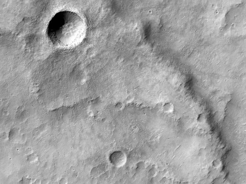
HiRISE Science Team wrote:Double Layer Ejecta in an Arabia Region Crater (ESP_024872_2175)
When impact craters form, they are generally surrounded by "ejecta": material that is thrown out from the crater by the impact and that settles onto the surrounding terrain. Sometimes there are multiple phases of material that fall to the ground (although both result from the same impact), creating the appearance of layered-ejecta.
This DLE [double layer ejecta] crater formed at the edge of an older/pre-existing crater, the rim of which deflected some of its ejecta. As it deflected the two phases of falling ejecta differently, we can use it to study how ejecta is transported and deposited. With HiRISE resolution, it may be possible for us to determine topography of the rim and then to see how high the barrier was that deflected some of the ejecta flow.
This is also an unusual crater because it is outside the Northern Plains and is relatively young.
This is a stereo pair with ESP_017356_2175.
HiRISE Science Team wrote:Fluvial Fan on a Crater Floor (ESP_024887_2155)
This observation shows a terrific fan-shaped deposit, beginning where the channel enters a crater. This is suggestive of a delta: a deposit that forms when water in a channel flows into a larger area (such as an ocean or a lake). As the water spreads out, it moves slower and drops the sediment that it is carrying, forming the delta. (E.g., a famous Earth example is the Nile River delta.)
The THEMIS instrument also photographed this area (I03235002), as well as the Context Camera (CTX) aboard the Mars Reconnaissance Orbiter. The resolution of HiRISE helps scientists determine the topography of the region which is needed for establishing the stratigraphic relations and flow direction of the area.
Here is a view of the terrain to the south of the craters in the full image.
Alfred McEwen and Ginny Gulick wrote:Dune Composition (ESP_025042_1375)
Sand dunes are among the most widespread aeolian (wind-formed) features present on Mars. Their spatial distribution and morphology are affected by changes in wind direction and wind strength. Patterns of dune erosion and deposition provide insight into the sedimentary history of the surrounding terrain.
This image shows sand dunes trapped in an impact crater in Noachis Terra. Dunes and sand ripples of various shapes and sizes, such as in this enhanced-color subimage, show the natural beauty created by physical processes.
This is a stereo pair with ESP_024976_1375.
Maria Banks wrote:Very Fresh Impact Crater Superposing a Wrinkle Ridge in Hesperia Planum (ESP_025237_1600)
The ridge captured in this HiRISE image is called a wrinkle ridge. This wrinkle ridge is located in Hesperia Planum, a region of over two million square kilometers (over 770,000 square miles) in the southern highlands of Mars. It is located northwest of the Hellas basin and adjacent to Tyrrhena Patera and contains abundant orthogonal and intersecting wrinkle ridges.
Wrinkle ridges are long, winding topographic highs and are often characterized by a broad arch with superposed narrow asymmetric ridges. These features have also been identified on the Moon, Mercury, and Venus. Their origin is attributed to horizontal compression or shortening of the crust due to faulting and folding. They commonly have asymmetrical cross sectional profiles and an offset in elevation on either side of the ridge.
Superposing or located on top of the wrinkle ridge, is a very fresh impact crater. We can tell that this crater is fresh because of its relatively sharp or crisp rim and unmodified shape. If you look closely, you can see faint rays of relatively fine material, boulders, and smaller secondary craters radiating from the crater and superposing the wrinkle ridge and older surrounding craters.
Credit: NASA/JPL/University of Arizona
<< Previous HiRISE Update


