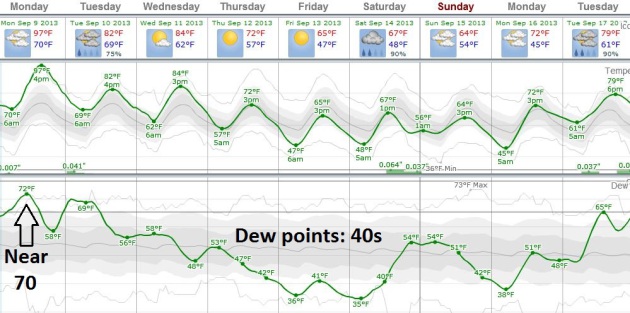
Re: Weather!
Posted: Sat Sep 07, 2013 3:55 am
Orin, take some BIG fans and point them east. I've got another night of just above freezing. 
It's supposed to start coolin Tuesday! For how long___; probably depends on the jet stream!Beyond wrote:Orin, where's the heatIt's down to 40F already, and it's not even midnight yet. BRRRR


http://www.washingtonpost.com/blogs/capital-weather-gang/wp/2013/09/19/super-typhoon-usagi-strongest-storm-of-2013-may-strike-hong-kong-sunday/ wrote:
Super typhoon Usagi, strongest storm in 2013, may strike Hong Kong Sunday
By Jason Samenow, The Washington Post: September 19 <<In the last 24 hours, a cyclone in the west Pacific has explosively intensified, and is on a track towards Hong Kong.
The storm – named Usagi – has achieved super typhoon status, after an amazing burst in its peak winds from 75 mph Tuesday to over 160 mph today. (Typhoons become “super typhoons” if their peak winds reach 150 mph or higher). It is now equivalent to a category 5 hurricane.
Usagi is now the strongest storm to form on Earth in 2013, more intense than Utor (peak winds of 150 mph) and Soulik (peak winds of 145 mph), also west Pacific typhoons.
The storm’s satellite presentation is immaculate, perfectly symmetric and accentuated with a pin-hole eye. As it heads due west, it is expected to maintain its strength for the next 24 hours. Then it might bend a bit to the north and begin to gradually weaken according to the Joint Typhoon Warning Center.
Usagi first has southern Taiwan in its sights. The center of the storm is forecast to pass just south of Taiwan, but its northeast quadrant – typically the most powerful, is likely to lash Taiwan’s south and east coast. Copious amounts of rain, damaging winds, and a substantial storm surge are possible there, particularly Saturday.>>
Wouldn't it be more correct to say warmer rather than bigger?rstevenson wrote:
We're in the 20s here too.
But our 20s are bigger than your 20s, so I'm still enjoying bike rides in the warm sun.
Me too. Even when the air temperature is in our 20s, the Sun is usually warm enough that no jacket is required. (Although I'm more likely to be on a horse than a bike.)rstevenson wrote:We're in the 20s here too. But our 20s are bigger than your 20s, so I'm still enjoying bike rides in the warm sun.
You don't get that white stuff in Sonoma; do you?BMAONE23 wrote:Not Yeti
BMAONE23 wrote:Every 5 years or so, the Geysers area and local mountains above 2000' or so will get a dusting that sticks for a day or so but that is about it. We are still well moderated by the marine influenceorin stepanek wrote:
You don't get that white stuff in Sonoma; do you?
Global Warming disrupting the jet streamhttp://en.wikipedia.org/wiki/Petaluma,_California wrote:
<<Although snow is rare in Petaluma, 1.5 inches fell in January 1916, as well as about 3 inches in January 2002.>>
Nature briefly overlapped three seasons.geckzilla wrote:That actually looks very strange to me like someone Photoshopped three different seasons together.
http://www.accuweather.com/en/weather-news/phailin-on-course-to-devastate-1/18611884 wrote:Tropical Cyclone Phailin Battering India, Turns Deadly
- [b][color=#0000FF]An Indian rickshaw puller carries people to a cyclone shelter near Chatrapur in Ganjam district about 200 kilometers (125 miles) from the eastern Indian city Bhubaneswar, India, Saturday, Oct. 12, 2013. Hundreds of thousands of people living along India's eastern coastline were taking shelter Saturday as a massive, powerful cyclone Phailin made landfall, packing destructive winds and heavy rains. (AP Photo/Biswaranjan Rout)[/color][/b]
By Eric Leister, Accuweather Meteorologist, October 12, 2013
<<Tropical Cyclone Phailin has made landfall in northeastern India, where a catastrophe threatens to unfold and deaths are already being reported.
The approach of Phailin, among the most powerful historical cyclones in the region, has led to the evacuation of about 500,000 people, according to the Australian ABC News website.
Destructive winds well over 160 kph (100 mph) and flooding rain of at least 200 mm (8 inches) likely targeted a substantial area spanning the site of the cyclone's landfall. A crippling storm surge of 4-6 meters (14-20 feet) may have swamped the coast near the point of landfall.
For much of Friday night into early Saturday afternoon, Phailin had been the equivalent to a Category 5 hurricane or super typhoon, but the storm weakened measurably prior to reaching land. The India Meteorological Department confirmed that Phailin made landfall in Gopalpur Saturday evening with winds over 200 kph (125 mph).
Now onshore, Phailin will continue to weaken as it tracks northwestward through northeastern India. Even so, Phailin will remain a dangerous storm with continued threats to lives and property. Torrential rain, capable of triggering life-threatening flooding, will continue to accompany Phailin as it tracks inland over northeastern India through Monday. Mudslides are also a concern in the higher terrain.
The areas expected to be thrashed by Phailin this weekend, specifically in an area from the cities of Visakhapatnam to Brahmapur to Puri is home to millions of people. Residents of these areas still have the memory of the 1999 Odisha cyclone fresh in their minds. This cyclone was also the equivalent of a Category 5 hurricane. The impacts were catastrophic and 15,000 were killed.>>