
Livio Tornabene, Ryan Hopkins, Kayle Hansen, Eric Pilles wrote:A Polar Smile (ESP_039115_0945) (HiClip)
This image represents one of many monitoring sites at the South pole residual cap (SPRC). Images are taken throughout the Martian year to document changes in carbon dioxide ice coverage.
This image shows a popular spot where one of the features resembles a smiley face that is approximately 500 meters across. If you smile at Mars, sometimes it smiles back.

Livio Tornabene, Ryan Hopkins, Kayle Hansen, Eric Pilles wrote:Strange Flow: Landslide, Impact Melt or Lava? (ESP_039117_1745) (HiClip)
This observation shows the full-width of a HiRISE image and its enhanced color strip, which only covers approximately 20 percent of the picture.
The image is approximately 6 by 6 kilometers and is located east of Noctis Labyrinthus, in a portion the large canyon system Valles Marineris. Visible in this image is a close-up of extensive deposits (some of which has a bluish color) that originated outside of the valley. These deposits appear to have flowed down towards low-lying areas and then bank up against higher topographic features.
Scientists are trying to determine if these deposits represent materials deposited by a massive landslide, an impact crater or a nearby volcanic event.

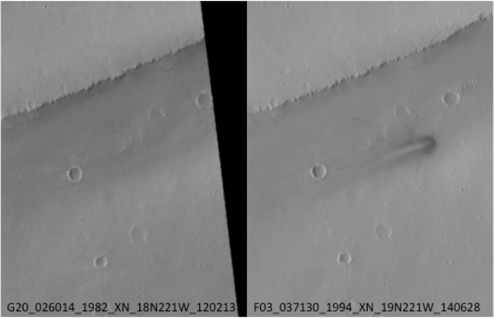
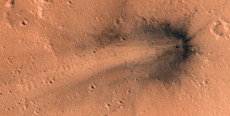
Eric Pilles, Livio Tornabene, Ryan Hopkins, Kayle Hansen wrote:A Recent Impact in Elysium Planitia (ESP_039148_1980) (HiClip)
This image shows a new impact crater in Elysium Planitia that was first discovered by the Mars Context Camera (CTX, also onboard the Mars Reconnaissance Orbiter) which formed between February 2012 and June 2014. It appeared as a dark streak with multiple secondary craters, which was not seen in the previous CTX image.
The HiRISE camera commonly monitors new impacts such as these; however this is the first image of this particular impact by HiRISE.
The image shows a very distinct crater rim and ejecta that is much darker than the surrounding dust-covered terrain. The distribution of the rayed ejecta suggests that the impactor struck from the west.

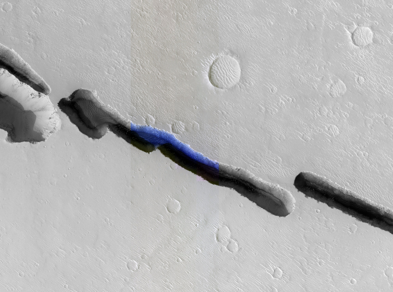
Kayle Hansen, Livio Tornabene, Eric Pilles, Ryan Hopkins wrote:The Eastern Portion of Cerberus Fossae (ESP_039187_1915) (HiClip)
Visible in this observation is a section of Cerberus Fossae (width approximately 250 meters), which are comprised of a series of rifts present located in Elysium Planitia just north the Martian equator. The fossae (Latin plural for a “ditch” or “depression”) are in close proximity and related to the formation of Athabasca Valles, which lies to the west. These rifts are collapse features believed to form by volcanic and tectonic processes.
In this composite image, we can see that the rift is not continuous, but discontinuous and offset. The offset could be the result of a preexisting subsurface discontinuity, such as a fault.
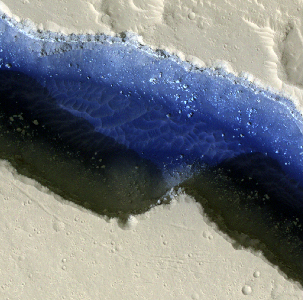
The close-up view of HiRISE infrared color shows us a plethora of information about Cerberus Fossae and the great amount of detail that HiRISE captures. The clear view of boulders strewn in shadowed areas of the rift is a testament to the high signal-to-noise capability and high resolution of the HiRISE camera; aeolian dunes along with boulders deposited from erosion of the rift walls are also visible in detail.
Using the pixel-length of the shadow within the rift, the incidence angle of the Sun at the time the image was taken, and some trigonometry, the approximate depth of the various sections of Cerberus Fossae can be estimated. Based on this simple method, an approximate depth is 260 meters. This estimate suggests that the rift is as wide as it is deep.
Another remarkable aspect of this image is the stark contrasts it captures: light-toned dusty surfaces that surround the rift versus the dark blue basaltic sands and the shadows within the rift. The detail that HiRISE can provide is indeed phenomenal, and as demonstrated here, the infrared color provides additional information. Why, for instance, is the floor of Cerberus Fossae a deep blue, and why is there such a contrast with the orange-grayish Martian surface? It's not water! The volcanic and mafic sand contains unoxidized iron, which appears a deep blue, while the Martian surface is covered by oxidized iron-bearing dust which appears orange-grayish.

Credit: NASA/JPL/University of Arizona
<< Previous HiRISE Update