Toasted wheat

Off topic discourse and banter encouraged.
Post Reply
User avatar
neufer
Vacationer at Tralfamadore
Posts: 18805
Joined: Mon Jan 21, 2008 1:57 pm
Location: Alexandria, Virginia

Toasted wheat

Post by neufer » Fri Apr 13, 2012 3:56 am

http://en.wikipedia.org/wiki/Dasht-e_Lut wrote:

<<Dasht-e Lut, also spelled Dasht-i-Lut, is a large salt desert in southeastern Iran and is the world's 25th largest desert.

Iran's geography consists of a plateau surrounded by mountains and divided into drainage basins. Dasht-e Lut is one of the largest of these desert basins, 480 kilometers long and 320 kilometers wide, and is considered to be one of the driest places on Earth.

Area of the desert is about 51,800 square kilometers. The other large basin is the Dasht-e Kavir. During the spring wet season, water briefly flows down from the Kerman mountains, but it soon dries up, leaving behind only rocks, sand, and salt.

The eastern part of Dasht-e Lut is a low plateau covered with salt flats. In contrast, the center has been sculpted by the wind into a series of parallel ridges and furrows, extending over 150 km and reaching 75 m in height. This area is also riddled with ravines and sinkholes. The southeast is a vast expanse of sand, like a Saharan erg, with dunes 300 m high, among the tallest in the world.

Measurements of MODIS (Moderate-Resolution Imaging Spectroradiometer) installed on NASA's satellite "Aqua" from 2003 - 2005 testify that the hottest land surface on Earth is located in Dasht-e Lut and land surface temperatures reach here 70.7 degrees C. Precision of measurements is 0.5 - 1 degrees K. The hottest part of Dasht-e Lut is Gandom Beryan - approximately 480 km² large plateau covered with dark lava. According to local legend this name (in translation from Persian - "Toasted wheat") originates from an accident where load of wheat left in the desert was scorched by the heat in a few days time.>>
http://earthobservatory.nasa.gov/IOTD/view.php?id=77627 wrote: <<According to the World Meteorological Organization (WMO), the highest temperature ever measured on Earth came on September 13, 1922, when the thermometer at a weather station in El Azizia, Libya, reached 58.0°C. That measurement shifted the title for “the world’s hottest place” away from Death Valley, California, which set the previous record (56.7°C) in July 1913. But more recent research says that neither location has a true claim to the title. “Most of the places that call themselves the hottest on Earth are not even serious contenders,” says Steve Running of the University of Montana.

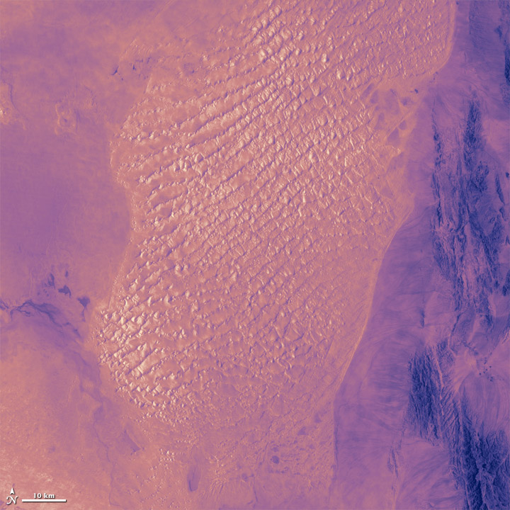
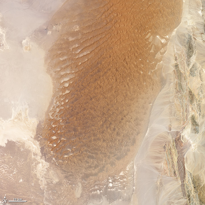
The images show a portion of the Lut Desert in Iran. The top image is infrared, while the bottom is natural color; both were acquired on July 6, 1999 by Landsat 7. In a study of seven years of global land surface temperatures as measured by satellites, the Lut Desert ranked as hottest in five of the years.

The Earth’s hot deserts—such as the Sahara, the Gobi, the Sonoran, and the Lut—are climatically harsh and so remote that access for routine measurements and maintenance of a weather station is impractical,” says David Mildrexler, also at the University of Montana. “The majority of Earth’s hottest spots are simply not being directly measured by ground-based instruments.”

That's where satellites come in. Orbiting instruments can scan every parcel of the planet's surface and fill in the gaps in global temperature measurements. In their analysis, Running, Mildrexler, and Maosheng Zhao scrutinized global measurements of land “skin” temperatures from 2003 to 2009. As opposed to air temperatures, which are measured 1.5 to 2 meters above the ground, land skin temperatures reflect the pure heating of a parcel of ground by radiation from the sun, the atmosphere, and other heat flows.

In five of the seven years—2004, 2005, 2006, 2007, and 2009—the highest surface temperature on Earth was found in the Lut Desert. The single highest LST recorded in any year, in any region, occurred there in 2005, when MODIS recorded a temperature of 70.7°C —more than 12°C warmer than the official air temperature record from Libya.

The University of Montana team found that the location of the world’s hottest spot can change from year to year, though the conditions don’t. Think dry, rocky, and dark-colored lands. In the images above from the Lut Desert, note how the dark, gravel-covered regions of the natural-color image show up as the brightest (and hottest) areas in the infrared imagery of the land surface in the lower image. Lightly vegetated areas (in green, at the right edge of the image) are darker and cooler in infrared because shade and transpiration—the release of moisture by plants—cool the surface slightly. Likewise, the brightest sands in the top image are comparatively cooler in infrared because they reflect more sunlight.>>
Art Neuendorffer

User avatar
Beyond
500 Gigaderps
Posts: 6889
Joined: Tue Aug 04, 2009 11:09 am
Location: BEYONDER LAND

Re: Toasted wheat

Post by Beyond » Fri Apr 13, 2012 4:57 am

Now wait just a hotter-than-hell minute, Art. How is it possible for Landsat 7 to take a horizontal picture of the land?? -The bottom picture-
If you tell me -crooked lense-, i'm not going to buy it.
To find the Truth, you must go Beyond.

User avatar
Chris Peterson
Abominable Snowman
Posts: 18601
Joined: Wed Jan 31, 2007 11:13 pm
Location: Guffey, Colorado, USA
Contact:

Re: Toasted wheat

Post by Chris Peterson » Fri Apr 13, 2012 5:03 am

Beyond wrote:Now wait just a hotter-than-hell minute, Art. How is it possible for Landsat 7 to take a horizontal picture of the land?? -The bottom picture-
If you tell me -crooked lense-, i'm not going to buy it.
The top and bottom images in the original article.
Chris

*****************************************
Chris L Peterson
Cloudbait Observatory
https://www.cloudbait.com

User avatar
Beyond
500 Gigaderps
Posts: 6889
Joined: Tue Aug 04, 2009 11:09 am
Location: BEYONDER LAND

Re: Toasted wheat

Post by Beyond » Fri Apr 13, 2012 8:56 am

Thanks chris. I do like the landlubbers picture that Art used, better. It's more earthy.
To find the Truth, you must go Beyond.

User avatar
orin stepanek
Plutopian
Posts: 8200
Joined: Wed Jul 27, 2005 3:41 pm
Location: Nebraska

Re: Toasted wheat

Post by orin stepanek » Fri Apr 13, 2012 1:08 pm

Beyond wrote:Thanks chris. I do like the landlubbers picture that Art used, better. It's more earthy.
Do you ever use Google Earth! Sometimes it is a lot of fun! You can go almost anywhere on Earth! When you zoom in and go to street level you can have a look see on many places on the planet. They must have had a lot of busy photographers because there is a lot of horizontal shots there. I even found my Brother's house in Fremont; and my Uncle's house in Reston Va. I even looked at street level shots in other countries. :D You can use up a lot of time doing this. :wink: 8-) All I could find of my house was the roof top because there wasn't any street level shot. :blah:
Orin

Smile today; tomorrow's another day!

Post Reply