
Ginny Gulick wrote:Crater with Surrounding Bench in Sinus Meridiani (ESP_023382_1845)
This image is located within Northern Sinus Meridiani, a region of ridged terrains and extensive stratigraphic layering.
Originally identified in a Mars Orbiter Camera image (MOC), this 10 kilometer (approximately 6 miles) diameter crater is surrounded by a prominent bench. As this HiRISE image shows, there is extensive layering in the upper cap units.
The bench formed because these layered surface units are eroding at a faster rate than the more resistant underlying materials that comprise the rest of the crater.
This is a stereo pair with ESP_023593_1845.

Ginny Gulick wrote:Light-Toned Layered Rock Outcrop in Ladon Valles (ESP_023383_1590)
Ladon Vallis, an approximately 600 kilometer (370 mile) long outflow channel, is part of a larger system that begins in Argyre basin to the south and extends northwards across the Southern Highlands towards the larger Ares Vallis outflow system. This image shows part of Ladon Vallis that is located within Ladon basin.
Here the extensive laterally continuous outcrops of layered light-tone units and deposits contrasts sharply with the darker-toned materials that cover the channel floor. Dark-toned dunes partly infill fractures and impact craters.
These extensive layers may have resulted from ponding of water and sediments that flowed into the basin from Ladon Vallis. Subsequent episodic flood events out of the basin to the north may have eroded and exposed the pre-existing sedimentary layers.
This is a stereo pair with PSP_006637_1590.

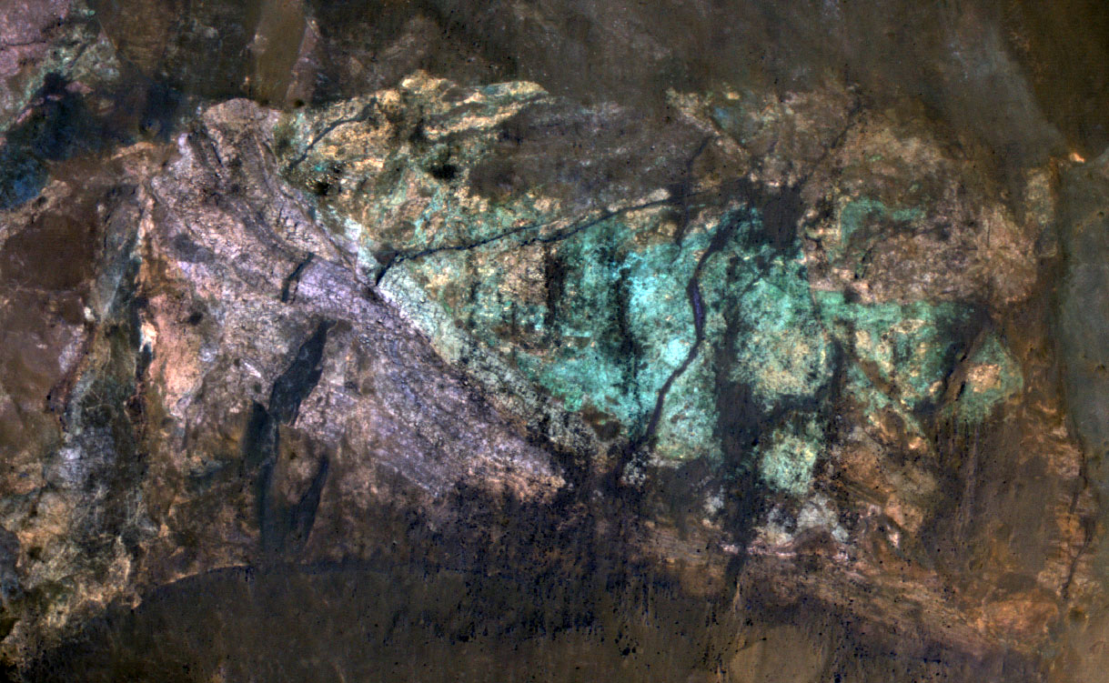
Ken Herkenhoff wrote:Colorful Central Peak in an Unnamed Crater (ESP_023674_1590)
Small impact craters retain their original bowl shape, but once a crater is large enough that the force of gravity on the slopes of the crater wall is greater than the strength of the target material, the wall collapses inward to form a central peak.
On Mars, the transition between simple (bowl-shaped) and complex craters is observed to occur at about 7-kilometer diameter. The formation of central peaks in complex craters brings up material from deep beneath the Martian surface. Therefore, central peaks of complex craters are good places to look for ancient rocks.
The colorful rocks exposed in the central peak visible in this image probably reflect variations in mineral content that were caused by water activity early in Mars' history. The CRISM hyperspectral image that was taken at the same time as this HiRISE image may show evidence for the various types of minerals that presumably are responsible for the colors visible here.

Kristin Block wrote:Spectacular Richardson Crater Dunes (ESP_023956_1075)
Richardson Crater is well-known among Mars scientists for its spectacular dunes.
These dunes are located around -72 degrees in latitude; if they were on Earth they'd be well south of the Antarctic Circle! Because of their extreme southern positioning, they endure dramatic temperature changes over the course of the Martian year. The HiRISE team attempts to monitor this area as these dunes get covered by seasonal frost in the fall and defrost in the spring, taking multiple images over the same locations in order to better understand the structure and evolution of these beautiful landforms.
This image was taken close to the Southern hemisphere autumnal equinox, the end of Southern hemisphere Summer and beginning of autumn. Unlike that observed on Earth, the frost seen on the Richardson Crater dunes is composed of carbon dioxide, and sublimates (goes directly from a solid to a gas) rather than melts. At the time of this image, the frost has likely disappeared to its greatest extent and will begin to re-acummulate soon.
Wide, dark streaks are visible extending from the crests of the dunes, likely due to movement of material as the dunes defrosted or to wind transportation of surface particles. Numerous dust devil tracks are still visible as thin, dark, criss-crossing marks, although these will gradually be covered by carbon dioxide frost as Southern hemisphere winter sets in.
The subimage is approximately 1 kilometer (about 0.62 miles) across. To see the previous image taken at this same location, taken in early Southern Hemisphere Spring as the dunes were thawing, see ESP_011785_1075. To take a look at other impressive dunes from various locations within Richardson Crater, see ESP_012774_1080, PSP_004230_1080, and ESP_012985_1075.

Credit: NASA/JPL/University of Arizona
PDS Release: October 2011 — (Orbit Ranges 23,500—23,899)
<< Previous HiRISE thread
