APOD: Geostationary Highway (2010 Feb 20)

Comments and questions about the APOD on the main view screen.
Post Reply
User avatar
APOD Robot
Otto Posterman
Posts: 5593
Joined: Fri Dec 04, 2009 3:27 am
Contact:

APOD: Geostationary Highway (2010 Feb 20)

Post by APOD Robot » Sat Feb 20, 2010 4:54 am

Image Geostationary Highway

Explanation: Put a satellite in a circular orbit about 42,000 kilometers from the center of the Earth (36,000 kilometers or so above the surface) and it will orbit once in 24 hours. Because that matches Earth's rotation period, it is known as a geosynchronous orbit. If that orbit is also in the plane of the equator, the satellite will hang in the sky over a fixed location in a geostationary orbit. As predicted in the 1940s by futurist Arthur C. Clark, geostationary orbits are in common use for communication and weather satellites, a scenario now well-known to astroimagers. Deep images of the night sky made with telescopes that follow the stars can also pick up geostationary satellites glinting in sunlight still shining far above the Earth's surface. Because they all move with the Earth's rotation against the background of stars, the satellites leave trails that seem to follow a highway across the celestial landscape. For example, in this wide view of the nearly equatorial Orion region, individual frames were added to create a 10 minute long exposure. It shows Orion's belt stars and well-known nebulae along with many 2.5 degree long geostationary satellite trails. The frames are from an ingenious movie, featuring the geostationary satellite highway.

<< Previous APODDiscuss Any APOD Next APOD >>
[/b]

User avatar
Chris Peterson
Abominable Snowman
Posts: 18599
Joined: Wed Jan 31, 2007 11:13 pm
Location: Guffey, Colorado, USA
Contact:

Re: APOD: Geostationary Highway (2010 Feb 20)

Post by Chris Peterson » Sat Feb 20, 2010 5:10 am

The image shows eight or ten geostationary satellites traveling along a path passing through M42. It shows another eight or ten that are at inclinations other than 0°, and are therefore not geostationary. These are either geosynchronous satellites, or formerly geostationary satellites that have been boosted out of the geostationary band in order to free up their spot for another satellite.
Chris

*****************************************
Chris L Peterson
Cloudbait Observatory
https://www.cloudbait.com

User avatar
neufer
Vacationer at Tralfamadore
Posts: 18805
Joined: Mon Jan 21, 2008 1:57 pm
Location: Alexandria, Virginia

Re: APOD: Geostationary Highway (2010 Feb 20)

Post by neufer » Sat Feb 20, 2010 1:30 pm

Chris Peterson wrote:The image shows eight or ten geostationary satellites traveling along a path passing through M42. It shows another eight or ten that are at inclinations other than 0°, and are therefore not geostationary. These are either geosynchronous satellites, or formerly geostationary satellites that have been boosted out of the geostationary band in order to free up their spot for another satellite.
http://en.wikipedia.org/wiki/Geostationary_orbit wrote:
<<Geostationary orbits can be achieved only very close to the ring 35,786 km high, directly above the equator. This equates to an orbital velocity of 3.07 km/s or a period of 1436 minutes, which equates to almost exactly one sidereal day or 23.934461223 hours. This makes sense considering that the satellite must be locked to the Earth's rotational period in order to have a stationary footprint on the ground. In practice this means that all geostationary satellites have to exist on this ring, which poses problems for satellites that will be decommissioned at the end of their service lives (e.g. when they run out of thruster fuel). Such satellites will either continue to be used in inclined orbits (where the orbital track appears to follow a [daily mini-analemma like] figure-of-eight loop centered on the equator), or else be elevated to a "graveyard" disposal orbit.>>
Art Neuendorffer

cybermystic
Asternaut
Posts: 4
Joined: Sat Feb 20, 2010 2:26 pm

Re: APOD: Geostationary Highway (2010 Feb 20)

Post by cybermystic » Sat Feb 20, 2010 2:29 pm

The guy's name is Arthur C Clarke (with an "e" on the end), please correct typo.
Greg

User avatar
neufer
Vacationer at Tralfamadore
Posts: 18805
Joined: Mon Jan 21, 2008 1:57 pm
Location: Alexandria, Virginia

Re: APOD: Geostationary Highway (2010 Feb 20)

Post by neufer » Sat Feb 20, 2010 2:53 pm

cybermystic wrote:The guy's name is Arthur C Clarke (with an "e" on the end), please correct typo.
Sir Arthur Charles Clarke (16 December 1917 – 19 March 2008)
---------------------------------------
http://en.wikipedia.org/wiki/Arthur_C._Clarke#Concept_of_the_geostationary_communications_satellite wrote:
<<Though different from Clarke's idea of telecom relay, the idea of communicating with satellites in geostationary orbit itself had been described earlier. For example, the concept of geostationary satellites was described in Hermann Oberth's 1923 book Die Rakete zu den Planetenräumen (The Rocket into Interplanetary Space) and then the idea of radio communication with those satellites in Herman Potočnik's (written under the pseudonym Hermann Noordung) 1928 book _The Problem of Space Travel_ : Providing for Long Distance Communications and Safety and (possibly referring to the idea of relaying messages via satellite, but not that 3 would be optimal) Observing and Researching the Earth's Surface published in Berlin. Clarke acknowledged the earlier concept in his book Profiles of the Future.>>
---------------------------------------
http://en.wikipedia.org/wiki/Herman_Poto%C4%8Dnik wrote:
<<Herman Potočnik (pseudonym Hermann Noordung) (December 22, 1892 - August 27, 1929) was a Slovene rocket engineer and pioneer of cosmonautics (astronautics). At the end of 1928, he published his sole book, Das Problem der Befahrung des Weltraums - der Raketen-Motor (The Problem of Space Travel - The Rocket Motor) in Berlin. The publisher, Richard Carl Schmidt, printed the year 1929 as a publishing date, probably from a purely business motive (to keep the book looking new throughout the coming year) and this date is often mistakenly given as the actual date of publication. In 188 pages and 100 handmade illustrations, Potočnik set out a plan for a breakthrough into space and the establishment of a permanent human presence there. He conceived a space station in detail and was the first man to calculate the geostationary orbit, on which the station would orbit the Earth. He described the use of orbiting spacecraft for detailed observation of the ground for peaceful and military purposes, and described how the special conditions of space could be useful for scientific experiments. Potočnik expressed strong doubts of the potentially destructive military use of these fresh discoveries.

The book was translated into Russian in early 1935, Slovene in 1986 (by the Slovenska matica), English in 1999 (by NASA) and Croatian in 2004 (by Marino Fonović, published by Labin Art Press). A partial translation in English, containing most of the essential chapters, was made as early as 1929 for the American magazine Science Wonder Stories and was issued in three parts (July, August and September 1929).

With his many ideas he became one of the founders of astronautics. His concepts were first taken seriously only by the amateur rocketry movement in Germany, the Verein für Raumschiffahrt (VfR - "Spaceflight Society"), centered on Hermann Oberth and his co-workers. In its Russian edition, the book may also have influenced Sergey Korolev's circle. More locally, Viennese engineers dismissed his work as fantasy.

Potočnik's book described geostationary satellites (first put forward by Konstantin Tsiolkovsky) and discussed communication between them and the ground using radio, but fell short of the idea of using satellites for mass broadcasting and as telecommunications relays (developed by Arthur C. Clarke in his Wireless World article of 1945). The wheel-shaped space station served as an inspiration for further development by Wernher von Braun (another former VfR member) in 1953. Von Braun saw orbiting space stations as a stepping stone to travel to other planets. In 1968, Stanley Kubrick's ground-breaking film, 2001: A Space Odyssey, depicted such a role for "Space Station V.">>

Description of a space station in Hermann Noordung's The Problem of Space Travel (1929).
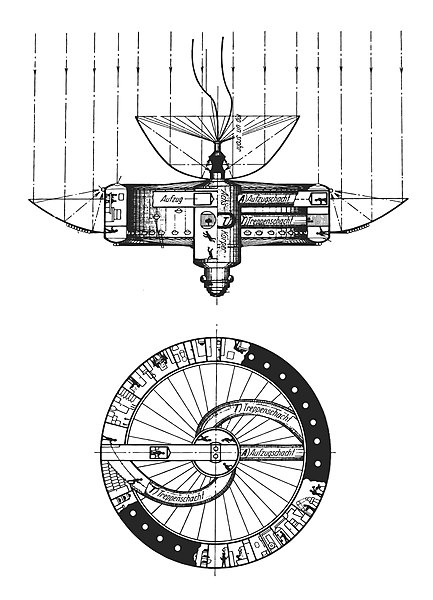
Image
(Legend: Achs-Körper: axle body. Aufzugschacht: elevator shaft. K: electric cable to an external observatory. Kondensatorrohre: condenser pipes. S: airlock. Treppenschacht: stairwell. Verdamfungsrohr: boiler pipe).>>
--------------------------------------------
Sir Arthur C Neuendorffere

NSS
Asternaut
Posts: 2
Joined: Sat Feb 20, 2010 2:58 pm

Re: APOD: Geostationary Highway (2010 Feb 20)

Post by NSS » Sat Feb 20, 2010 3:07 pm

I have a question,

If they are geostationary, then why are they moving? Therse streaks all must be the dead de commissioned birds getting out of the way. As they say.

Because if they are moving they are useless to the end users on the ground.

Just like the birds for like Direct TV or Dish network.

I install these and just a degree error makes enough signal difference that it's the difference between seeing the signal and not seeing it.

And these streaks are far more than a degree of movement.

Joe
Near Space Sciences

User avatar
Chris Peterson
Abominable Snowman
Posts: 18599
Joined: Wed Jan 31, 2007 11:13 pm
Location: Guffey, Colorado, USA
Contact:

Re: APOD: Geostationary Highway (2010 Feb 20)

Post by Chris Peterson » Sat Feb 20, 2010 3:37 pm

NSS wrote:If they are geostationary, then why are they moving? Therse streaks all must be the dead de commissioned birds getting out of the way. As they say.
They are moving because the camera was moving. If you were to turn off the telescope drive, you'd see the geostationary satellites as points of light and it would be the stars that are streaked.

The objects moving along a common line are probably all active geostationary satellites or decommissioned ones in higher orbits (which would not be apparent in such a short exposure). The ones off that line are either decommissioned geostats (moved to different inclinations), or more likely they are active geosynchronous satellites. With their inclinations so near 0°, they would appear to have the same path length as geostats in this short exposure.
Chris

*****************************************
Chris L Peterson
Cloudbait Observatory
https://www.cloudbait.com

NSS
Asternaut
Posts: 2
Joined: Sat Feb 20, 2010 2:58 pm

Re: APOD: Geostationary Highway (2010 Feb 20)

Post by NSS » Sat Feb 20, 2010 3:56 pm

Wow thats right Like DUH? geech, too early in the morning!

sorry all!

Joe

biddie67
Science Officer
Posts: 483
Joined: Sun Jan 31, 2010 9:44 am
Location: Possum Hollow, NW Florida

Re: APOD: Geostationary Highway (2010 Feb 20)

Post by biddie67 » Sat Feb 20, 2010 4:54 pm

This photograph was a great "learning-lesson" for me. I think that it was taken in the northern hemisphere, looking south with the camera and stars sweeping westward to the right ((?))...

It took me a while to realize why the geosync'd satellites left trails and the stars didn't.

And thanks for all the extra info above - it's a great bit of the history behind the development of the ideas!

biddie67
Science Officer
Posts: 483
Joined: Sun Jan 31, 2010 9:44 am
Location: Possum Hollow, NW Florida

Re: APOD: Geostationary Highway (2010 Feb 20)

Post by biddie67 » Sat Feb 20, 2010 5:05 pm

But now I have what probably seems like a dumb question but:

From the original text ..
Because that matches Earth's rotation period, it is known as a geosynchronous orbit. If that orbit is also in the plane of the equator, the satellite will hang in the sky over a fixed location in a geostationary orbit.
If a satellite is in a geosynchronous orbit with the Earth but off the plane of the equator, wouldn't it still appear geostationary to an observer on the Earth? I'm guessing that its elevation and speed might be different than the official geostationary satellites ????

User avatar
Chris Peterson
Abominable Snowman
Posts: 18599
Joined: Wed Jan 31, 2007 11:13 pm
Location: Guffey, Colorado, USA
Contact:

Re: APOD: Geostationary Highway (2010 Feb 20)

Post by Chris Peterson » Sat Feb 20, 2010 5:17 pm

biddie67 wrote:If a satellite is in a geosynchronous orbit with the Earth but off the plane of the equator, wouldn't it still appear geostationary to an observer on the Earth? I'm guessing that its elevation and speed might be different than the official geostationary satellites ????
No. Consider the extreme example of a geosynchronous satellite in a polar orbit (inclination = 90°). This means that if it is over the north pole at a given time, it will be over the south pole 12 hours later. Clearly, and observer on the ground will see it moving both north/south (due to the satellite's orbital motions), and east/west (due to Earth's rotation).

A more typical geosynchronous satellite will have a small (but non-zero) inclination. Picture its orbit, and you'll see that it must be north of the equator for half the time, and south of it for the other half. So it obviously bobs up and down north-to-south. There will also be a slight E/W motion, which might be a little harder to visualize. As noted elsewhere, the actual pattern traced on the sky looks like an analemma. This pattern becomes larger as the inclination gets larger.

There is no possible way to achieve a geostationary orbit except over the equator. Life would be much easier if that were not the case, since companies like DirectTV would simply park a satellite over the middle of the U.S. But they can't.
Chris

*****************************************
Chris L Peterson
Cloudbait Observatory
https://www.cloudbait.com

User avatar
Chris Peterson
Abominable Snowman
Posts: 18599
Joined: Wed Jan 31, 2007 11:13 pm
Location: Guffey, Colorado, USA
Contact:

Re: APOD: Geostationary Highway (2010 Feb 20)

Post by Chris Peterson » Sat Feb 20, 2010 5:35 pm

biddie67 wrote:I think that it was taken in the northern hemisphere, looking south with the camera and stars sweeping westward to the right ((?))...
Correct. In fact, looking at the declination of the geostationary satellites in the image (-5.3°) makes it possible to calculate the latitude of the camera: N 32.4°. That is consistent with central Iran, the home country of the imager.

If you were on the equator, the geostationary band would be at declination 0°, and directly across the zenith. As you move north, the declination decreases, and as you move south it increases. At the north pole, the band would appear at declination -8.6°, which is below the horizon.
Chris

*****************************************
Chris L Peterson
Cloudbait Observatory
https://www.cloudbait.com

User avatar
neufer
Vacationer at Tralfamadore
Posts: 18805
Joined: Mon Jan 21, 2008 1:57 pm
Location: Alexandria, Virginia

Re: APOD: Geostationary Highway (2010 Feb 20)

Post by neufer » Sat Feb 20, 2010 5:37 pm

Chris Peterson wrote:There is no possible way to achieve a geostationary orbit except over the equator.
http://en.wikipedia.org/wiki/Statite wrote:
<<A statite (a portmanteau of static and satellite) is a hypothetical type of artificial satellite that employs a solar sail to continuously modify its orbit in ways that gravity alone would not allow. Typically, a statite would use the solar sail to "hover" in a location that would not otherwise be available as a stable geosynchronous orbit. Statites have been proposed that would remain in fixed locations high over Earth's poles, using reflected sunlight to counteract the gravity pulling them down.

Image
The concept of the statite was invented by Robert L. Forward. No statites have been deployed to date, as solar sail technology is still in its infancy.>>
The optimal position of a statite satellite by my calculation would be 428 earth radii above the northern/southern hemisphere. The acceleration thrust required to maintain a geostationary orbit here would amount to ~ 1/61,000 [=3/(4282)] of a g or about twice the acceleration of the Dawn spacecraft. (Unfortunately, an ion exhaust plume would probably get in the way of communications.)
http://en.wikipedia.org/wiki/Ion_thruster wrote:
<<Dawn was launched on 27 September 2007 to explore the asteroid Vesta and the dwarf planet Ceres. To cruise from Earth to its targets it uses three Deep Space 1 heritage Xenon ion thrusters (firing only one at a time) to take it in a long outward spiral. Dawn's ion drive is capable of accelerating from 0 to 60 mph (97 km/h) in 4 days.>>
Last edited by neufer on Sat Feb 20, 2010 10:35 pm, edited 2 times in total.
Art Neuendorffer

User avatar
BMAONE23
Commentator Model 1.23
Posts: 4076
Joined: Wed Feb 23, 2005 6:55 pm
Location: California

Re: APOD: Geostationary Highway (2010 Feb 20)

Post by BMAONE23 » Sat Feb 20, 2010 5:42 pm

Orca posted this link in the Social Bookmarks section earlier. It has been in my favorites for a couple of years now.
http://science.nasa.gov/realtime/jtrack ... ack3D.html
Once the site opens, A second window will open with the satellite location Java app and the Live Locations will appear.
Notice the Ring of Satellites surrounding the Equator. These are the Geostationary Satellites. Those slightly above
or below this plane are the Equitorial Geosynchronous Satellites.
Funny thing is, If you were stationed at the right one of these Geostationary satellites, you would see a particular
geosynchronous satellite traveling up and down in its orbit.
Relative to you, the sattelite would take 6 hours to rise above you then another 6 hours to fall back to your position,
then another 6 hours falling below you, and finally another 6 hours to rise back to your position.

User avatar
neufer
Vacationer at Tralfamadore
Posts: 18805
Joined: Mon Jan 21, 2008 1:57 pm
Location: Alexandria, Virginia

Tom Swift and his Outpost in Space (1955)

Post by neufer » Sat Feb 20, 2010 6:49 pm

http://www.tomswift.info/homepage/outpost.html wrote:
Image
  • "Tom," said his father, "Mr. William Bruce is from the Consolidated Broadcasting Network, and is chairman of this committee of engineers from the major broadcasting companies. They've come to discuss a very important problem with us."

    The group took seats, then Mr. Bruce addressed the Swifts. "I'll state our problem at once. As you know, high-frequency-signal coverage in its present form is far from being efficient. Distances are short, requiring many relay stations. Sometimes there's distortion. Also, sunspots or magnetic storms may wreck the broadcast completely."

    "In fact," he went on, "any reliable system of short-wave broadcasting over great distances is practically hopeless with our present methods. However, there's one solution to this problem--"Though as a scientist, you've no doubt guessed what I'm about to propose."

    "A space station?" Tom burst out in his enthusiasm.

    Bruce nodded. "Exactly. Our committee has come to the conclusion that it's the only way we can hope to lick our broadcasting troubles--that is, by setting up a platform in space to which we can beam radio signals and have them relayed directly back to earth. Naturally, this would be a huge project. But we feel that Swift Enterprises is well fitted to undertake the job.">>
----------------------------------------------------------------
<<Summary: Extracted from the dustjacket of the book:
  • A space station 22,300 miles above the earth is Tom Swift Jr.'s latest project!

    Tom's plans for his gigantic hub-and-spoke outpost of the universe calls for twelve laboratories. Solar batteries will be produced in one laboratory, another will be a celestial observatory, and another a radio broadcasting and TV station relaying programs over one third of the earth.

    But the project is beset from the start by a fiendish enemy, and also that weird phantom of outer space, Zero Gravity.

    Tom comes to grips with the problem of weightlessness by inventing a Zero chamber. Here, in order to master the helpless feeling encountered in space, men are trained to develop a new set of muscular reflexes. Crewmen crawling like flies up and down the walls and across the ceiling of Zero G creates momentary comic relief.

    But this is only a prelude to an exciting drama which takes place on a Pacific island, where Tom's rocket fleet is about to blast off. Strange warnings that terrify the natives nearly wreck Tom's plans. How the young scientist overcomes all obstacles and launches his space station makes a gripping book. And each technical detail of this fascinating story has been carefully checked. For those who enjoy the thrill of adventure and the chill of mystery, Outpost In Space is must reading.>>
Art Neuendorffer

User avatar
Chris Peterson
Abominable Snowman
Posts: 18599
Joined: Wed Jan 31, 2007 11:13 pm
Location: Guffey, Colorado, USA
Contact:

Re: APOD: Geostationary Highway (2010 Feb 20)

Post by Chris Peterson » Sun Feb 21, 2010 12:01 am

neufer wrote:
Chris Peterson wrote:There is no possible way to achieve a geostationary orbit except over the equator.
The optimal position of a statite satellite...
There are any number of ways to place an object in a geostationary position if you have energy available to keep it there, and an active control system. But I wouldn't use the term "orbit" to describe the path of a statite satellite.
Chris

*****************************************
Chris L Peterson
Cloudbait Observatory
https://www.cloudbait.com

User avatar
neufer
Vacationer at Tralfamadore
Posts: 18805
Joined: Mon Jan 21, 2008 1:57 pm
Location: Alexandria, Virginia

Re: APOD: Geostationary Highway (2010 Feb 20)

Post by neufer » Sun Feb 21, 2010 12:52 am

Chris Peterson wrote:
neufer wrote:
Chris Peterson wrote:There is no possible way to achieve a geostationary orbit except over the equator.
The optimal position of a statite satellite...
There are any number of ways to place an object in a geostationary position if you have energy available to keep it there, and an active control system. But I wouldn't use the term "orbit" to describe the path of a statite satellite.
  • orbit: The line followed by a spacecraft or a celestial body.

    orbit: the path that an object makes, around another object, while under the influence of some force.

    ORBIT, n. [L. orbita, a trace or track, from orbis, a wheel.] In astronomy, the path of a planet or comet;
    the curve line which a planet describes in its periodical revolution round its central body.
    Webster's Revised Unabridged Dictionary (1828)
By "optimal position of a statite satellite" I mean the one that requires the least amount of thrust.
Right now an ion rocket could produce the necessary thrust but solar sails can not.

(It would certainly be a great place from which to observe aurorae.)
Art Neuendorffer

User avatar
rstevenson
Quis custodiet ipsos custodes?
Posts: 2705
Joined: Fri Mar 28, 2008 1:24 pm
Location: Halifax, NS, Canada

Re: Tom Swift and his Outpost in Space (1955)

Post by rstevenson » Sun Feb 21, 2010 2:45 am

neufer wrote:Image
Thanks for that!

I had a bunch of Tom Swift Jr. books when I was a kid, and even one tattered old Tom Swift and His Great Searchlight book from early in the 20th century. That cover is one that I had. Nice to see it again. :D

Rob

evofxdwg
Asternaut
Posts: 1
Joined: Sun Feb 21, 2010 4:25 am

Re: APOD: Geostationary Highway (2010 Feb 20)

Post by evofxdwg » Sun Feb 21, 2010 4:40 am

Fascinating! I never even thought about the diff in geostationary and geosync.
But now the following is hurting my head:
The movie appears to have 3 main orbital planes (along with some apparently less used orbits). Based on discussion above, two of them are geosynchronus but not geostationary. If they all have the same orbital period (1 day), dont each pair of orbital rings have to cross each other at two points, leading to a high probability of collision?

If so, how is collision avoided? Is the timing of the different planed oribts a Keystone Cops scenario where they ensure there are never two satellites from different orbits at the orbit crossover point?

I dont know anything about how often a satellite has to be "moved" or corrected. But if some of these are old "junk" they cannot be moved anymore....right?

User avatar
Chris Peterson
Abominable Snowman
Posts: 18599
Joined: Wed Jan 31, 2007 11:13 pm
Location: Guffey, Colorado, USA
Contact:

Re: APOD: Geostationary Highway (2010 Feb 20)

Post by Chris Peterson » Sun Feb 21, 2010 5:44 am

evofxdwg wrote:The movie appears to have 3 main orbital planes (along with some apparently less used orbits). Based on discussion above, two of them are geosynchronus but not geostationary. If they all have the same orbital period (1 day), dont each pair of orbital rings have to cross each other at two points, leading to a high probability of collision?
I would think that it is only geostationary satellites that need to be placed in an orbit of precise radius. For geosynchronous satellites that don't need to be stationary, they can probably put them in slightly higher or lower orbits. For many applications, there is probably no difference between geosync and almost geosync. A few kilometers will make almost no difference in period (or it will be correctable), but all the difference in avoiding collisions.
I dont know anything about how often a satellite has to be "moved" or corrected. But if some of these are old "junk" they cannot be moved anymore....right?
Because the slots in the geostationary belt are so valuable, they try very hard to avoid dead satellites getting stuck there. All geostats have a planned end of life procedure. Of course, satellites can and do fail prematurely, so there are dead ones that never get moved.
Chris

*****************************************
Chris L Peterson
Cloudbait Observatory
https://www.cloudbait.com

Oldfart
Ensign
Posts: 10
Joined: Fri Nov 07, 2008 5:34 am

Re: APOD: Geostationary Highway (2010 Feb 20)

Post by Oldfart » Sun Feb 21, 2010 6:17 am

Chris, perhaps we'll need to send a "janitor" satellite up there someday to sweep up the dead stuff. Or will the dead ones drift away within a reasonable time due to being perturbed by the moon and sun's gravity?

OF

User avatar
Chris Peterson
Abominable Snowman
Posts: 18599
Joined: Wed Jan 31, 2007 11:13 pm
Location: Guffey, Colorado, USA
Contact:

Re: APOD: Geostationary Highway (2010 Feb 20)

Post by Chris Peterson » Sun Feb 21, 2010 6:46 am

Oldfart wrote:Chris, perhaps we'll need to send a "janitor" satellite up there someday to sweep up the dead stuff. Or will the dead ones drift away within a reasonable time due to being perturbed by the moon and sun's gravity?
There is negligible drag in high orbits, so decay rates are measured in thousands or even millions of years. There are perturbations from the Earth, Sun, and Moon that require periodic orbit corrections, but I don't think you'd want to depend on them to clear debris from a geostationary orbit before a collision might occur. I've read that some sort of active cleanup mechanism (like your janitor satellite) may be required in the future. In the meantime, they just try to attain a graveyard orbit for satellites at the end of their operational lives.
Chris

*****************************************
Chris L Peterson
Cloudbait Observatory
https://www.cloudbait.com

Motanius

Re: APOD: Geostationary Highway (2010 Feb 20)

Post by Motanius » Thu Jan 30, 2014 2:08 pm

http://twanight.org/newTWAN/case.asp

Everything I'm seeing in this video makes sense to me except for this: One satellite bottom center of vid. As per the creator, "All of the satellites in this highway has moved about 2.5 degrees during the 10 minute shooting period, equal to 360 degrees for a complete 24 hours." As can be seen this is true for almost every streak. All progression is almost uniform, even off geostat. This does not apply to the satellite I'm seeing however. This satellite easily moves twice that distance over the course of the video, yet appears to follow the same path as the others. Why is that?

User avatar
neufer
Vacationer at Tralfamadore
Posts: 18805
Joined: Mon Jan 21, 2008 1:57 pm
Location: Alexandria, Virginia

Re: APOD: Geostationary Highway (2010 Feb 20)

Post by neufer » Thu Jan 30, 2014 3:36 pm

Motanius wrote:
http://twanight.org/newTWAN/case.asp

Everything I'm seeing in this video makes sense to me except for this: One satellite bottom center of vid. As per the creator, "All of the satellites in this highway has moved about 2.5 degrees during the 10 minute shooting period, equal to 360 degrees for a complete 24 hours." As can be seen this is true for almost every streak. All progression is almost uniform, even off geostat. This does not apply to the satellite I'm seeing however. This satellite easily moves twice that distance over the course of the video, yet appears to follow the same path as the others. Why is that?
There is another fast satellite passing through the Flame Nebula.

These are possibly semi-synchronous satellites.
http://en.wikipedia.org/wiki/Geosynchronous_orbit wrote:
<<A semi-synchronous orbit has an orbital period of 1/2 sidereal day, i.e., 11 h 58 min. Relative to the Earth's surface it has twice this period, and hence appears to go around the Earth twice every day. Examples include the Molniya orbit and the orbits of the satellites in the Global Positioning System.>>
Art Neuendorffer

Mortanius

Re: APOD: Geostationary Highway (2010 Feb 20)

Post by Mortanius » Thu Jan 30, 2014 5:04 pm

Ah! Thank you muchly. For some reason I couldn't wrap my head around the differences.

/brainfart.exe ftw...

Post Reply